The Transcribed Diary of
Eli Casey Cooley
as he came across the Oregon Trail and the Meek Cutoff
in 1845
by Michael F. and Mary Lou Cooley
for the
Officer-Cooley Family Association
November 2004
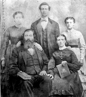
Eli Casey and Lydia Ann (Bonney) Cooley
With children Laura Eveline “Eva”, Benjamin F. & Mary Emeline
Circa 1870
The Transcribed Diary of Eli Casey Cooley
as he came across the Oregon Trail and the Meek Cutoff
in 1845
By Michael F. and Mary Lou Cooley for the Officer-Cooley Family Association
November 2004
Introduction
An estimated 3000 emigrants traveled over the Oregon Trail to the Oregon Territory in 1845. This was the biggest migration to date and it is said to have doubled the non-Indian population of the territory.
Most of the 1845 emigrants followed the traditional route of the Oregon Trail up the Platt River from Missouri, through South Pass in the Rocky Mountains and then down the Snake River and its upper tributaries to Fort Boise. From there they crossed the Snake River, proceeded up the Burnt River into the Grande Ronde Valley and then over the Blue Mountains eventually reaching The Dalles, Oregon at the east end of the Columbia River Gorge. At that point they abandoned their wagons and went down the Columbia River by canoe or boat to Ft Vancouver and eventually the Willamette Valley. But a mountain man and adventurer named Stephen Meek talked a significant portion of the 1845 emigrants into following him across eastern and central Oregon on what he described as an easier shortcut to the Willamette valley which would avoid the dangers of rumored Indian hostilities in the Blue Mountains and save time and mileage. Unfortunately, the supposed shortcut turned into disaster when Meek became lost and lead them onto a nearly waterless route where people became sick and began to die. The hardships were magnified by the fact that 1845 was an extremely dry year and they were crossing the desert area of eastern, Oregon during the driest part of the year. The route Meek followed has become known as the Meek Cutoff and is probably the most infamous passage across the Oregon Territory on record. The number of emigrants that died on the trip is estimated to range from 23 to 50 people. At the high end that is more than died in the better known Donner Party disaster crossing the Sierra Mountains in 1846.
Eli Casey Cooley and his extended family were on the trip over the Meek Cutoff in 1845.
About the Officers and the Cooleys
The Officer and the Cooley families were in what became Missouri as early as 1811. This location at the eastern beginning of the Oregon Trail placed them perfectly to be swept up by the migration of emigrants across the continent that began in the early 1840's. Those Officers and Cooleys that made the perilous journey in 1845 were:
We know that the Officers and Cooleys joined an Association in Missouri which was named the Savannah Oregon Emigrating Society to make the trip to Oregon. All of the adult male Officers and Cooleys are listed in the Constitution for that Society. We also know that Solomon Tetherow was elected Captain of the wagon train which was usually referred to as a Company. There is also some evidence that Stephen Meek was hired as a guide for the Company starting in Missouri but was not in their employ by the time they reached Ft. Hall along the Snake River. In addition, we know that wagon train companies often split or merged after they left Missouri for a whole range of reasons including different traveling speeds and various disagreements and disputes. There is evidence in Eli Casey Cooley's diary that Eli followed Solomon Tetherow across the Meek Cutoff. The route taken by Solomon Tetherow is of historic significance because it is different than the route followed by most other emigrants over the Meek Cutoff. Eli's diary finally may solve the mystery that has existed over the route taken by Solomon Tetherow.
We like to think that the Officers and Cooleys stayed together as a tight knit family for the whole passage. This would have allowed the single adult males like Jackson L. and Eli Casey Cooley to help Christopher Columbus Cooley and James Officer with there large families. There is some evidence that this did indeed happen but it cannot be proven with certainty. We do know that Christopher Columbus, Jackson L. and Eli Casey Cooley took up adjacent homesteads near present day Woodburn, Oregon after they reached the Willamette Valley. And James and Evaline Officer were only a short distance away near present day Molalla, Oregon. Mathias lived with Jackson L. Cooley for a time and eventually settled near present day Silverton, Oregon.
About the Officer-Cooley Family Association
The Officer-Cooley Family Association consists of descendants and spouses of the Officers and Cooleys who came to Oregon by the Oregon Trail and the Meek Cutoff in 1845. We have been meeting every year since 1967 in an annual family reunion held somewhere in the northwest to celebrate our common ancestry and exchange information. Among our membership there is a wealth of information on family history which we are always glad to share or add to. We maintain an extensive Email and ground mail mailing list. Our interests are strictly noncommercial and we maintain our reunion by voluntary contributions. Many of the members of the Association are active family historians and genealogists.
Other Sources of Information
There have been a number of books written about the 1845 migration over the Oregon Trail. Also, there are a number of diaries available either over the internet or through purchase from the Oregon Historical Society. Some of these documents were used to help interpret or clarify Eli Casey Cooley's diary. They include:
Special Thanks
A special thanks is given to Mrs. Grace Armstrong, a great grandchild of Eli Casey Cooley, who inherited the diary from her mother and gave us a copy with permission to transcribe and share it widely. As far as we know, no previous copy of the diary has left the family or ever been shared in this manner.
I would also like to give a special thanks to my wife Mary who labored over the typing and original transcription of Eli Casey Cooley's diary into a readable document.
About the Transcription
We have endeavored to maintain the original diary the way it was written in 1845 even down to misspelled words and grammatical errors. However, where we thought a word might not be understandable because of the spelling, we have shown the correct spelling in parentheses. We tried to do this only once per word. We have also added some notes in bold type where we thought they would add to understanding by the reader. In addition, there are some comments in brackets that describe entries in the margins, torn pages, smears, and erasures etc.
/s/ MICHAEL F. & MARY LOU COOLEY
Michael F. Cooley, President and Mary Lou Cooley
Officer-Cooley Family Association
Grants Pass, Oregon
Diary of Eli Casey Cooley
Entitled: “Journal of the Savannah Oregon Emigrating Company
Page 1:
Away and away to the settting sun h.h.h.
Our troops are bound for the Oregon h.h.h.
On the Rocky Mountains Snow Capt (Capped) Highth (Height)
Our flag shall stream in the morning light
And over the plains of Oregon. h.h.h.
Away and a day for a thousand miles. h.h.h.
To the climes whare Summer ever smiles. h.h.h.
For a few stout harts can lead the mass
Thrugh the hostile Tribes and the Mountains pass
Away and away for the Oregon. h.h.h.
This poem was written in Eli's hand at the beginning of the Diary but we don't know if he was the original author or if he copied it from some other source.
Journal of the Savannah Oregon Emigrating Company
The Company consist of 66 Wagons and ---____ Men ____ Women and Children ____ and the whole amount of persons belonging to the Company is ____
Amount of Stock ____
Head of Horses: ___ Mules: ____ ____Yoke of Cattle and ____ Head of loose Cattle
Eli evidently never finished filling in the above census. Fred Lockley documented a census of 66 wagons, 100 armed men, 293 persons, 63 women under 14, 56 women over 14, 624 loose cattle, 398 oxen, 74 horses and mules and 170 guns & pistols for this Company. The title “Journal of the Savannah Oregon Emigrating Company” was written by Eli at the start of the diary and raises an interesting question. Was Eli assigned or appointed to be the official journal keeper for the Company? If that was the case it was not documented in the Company's constitution.
May 6th 1845 Tue.
The Company left the place of Rundeyvases (rendezvous) on Wolf River and proceeded on their Journey and camped at Brush Point. Common rode (road). Weather fine; water and wood plenty. One wagon broke; oxen bolt (bolted) but got in to camp at night. One ox killed.
Traveled 6 miles.
It was said that the wagons did not roll until the rivers were down and the grass was up. The emigrants had to be able to ford the rivers and feed their large herds of stock. Most wagon trains left the Missouri area between late April and the middle of May in order to reach their destination before winter. A late start could be fatal.
It was a normal practice to assign a child to walk alongside one of the wagons and count the number of revolutions that a wheel made over the day. The emigrants knew how many revolutions it took to make a mile and in this fashion were able to approximate their daily mileage. Since Eli had lots of nieces and nephews on the trek, he probably used them for counting the revolutions.
Wed 7th May
Nothing of any importance occurred to day. First rate rode (road). Weather good. Camped at Holy Creek. Wood and water plenty.
10 miles
Thu 8th May
The Company camped on Oak Branch. Road First Rate. Weather fine; wood and water plenty.
10 miles
Fri 9th May
The Company camped on the Main Fork of Wolf River. Water & wood plenty; road first rate; weather fine.
10 miles
Sat 10th May
The Company laid by to day for the purpose of other wagons overtaking. Here was the first Seder (Cedar) wood on Wolf River. Weather fine.
Juniper trees were referred to as cedars.
Sun 11th May
The Company traveled to day but gained but verry (very) little. They left the divide and started down the Nimahaw and had to turn back. Traveled about 12 miles but have gained but about 5. The rode is first rate; weather good. Camped on the head of the East fork of the Nimahaw. Wood and water plenty.
5 miles
The diary of Jesse Harritt mentions the Wolf River on May 3 and the Nimahaw on May 10. James Field's diary mentions crossing both forks of the Nimahaw on May 6.
Mon 12th May
The Company traveled to day. The rode is first rate. Wee had a sprinkle of rain this morning but the day has been fine for traveling. Camped on the Second fork of the Nimahaw - wood and water was plenty. When the Company was forming at night a small child of Mr. Hall's fell out of the wagon and the wheel ran over it's head; which at this time there is no life expected. A sprinkle of rain to night.
14 miles
A Benny and a Benjamin F. Hall are listed in the Company census.
Tue 13th May
The Company traveled to day over a first rate rode; weather fine. Camped on the head [“of the East fork of Caw River” marked out] of a small creek that empties in -?- [corner of page torn off]. Wood and water plenty.
12 miles
Wen 14th May
Wee traveled to day. The rode is first rate; weather fine. Wee crossed the main channel of the Nimahaw with out any difficulty and camped on the west side of it - wood and water plenty.
8 miles
Thu 15th May
Wee traveled to day and crossed a prong of the Little Blue; 3 m and 2 m crossed another prong [“The main Creek” marked out]. Wood plenty at both places and 1 ½ miles come to Burnett's trace and went 1 ½ miles and camped on a prong of the Blue. Some wood and first rate water; weather fine; rode first rate with the exception of the creeks and wee crossed them with out mutch (much) difficulty.
8 miles
Fri 16th May
Wee traveled to day. Crossed several streams to day. 2 miles crossed the little blue and six miles crossed and other (another) prong and camped on the west side of it. Wood plenty; the rode has been quite broken to day; weather fine. One ox killed tonight. Mr. Hall's child that got [“got” written over “fell”] hurt by the wagon has recovered.
8 miles
Sat 17th May
Traveled today. Wee come 4 miles and crossed big blue with out any difficulty and went 4 miles and camped on the head of a branch of blue. Wood plenty. The rode is broken. Wee had some rain today. The name blue should be Caw.
8 miles
Sun 18th May
The rode has been tolerable good today. Weather fine. Camped on a Branch of Blue. Met 6 wagons from the mountains. Wood and water was plenty.
8 miles
Other diary's have mentioned meeting a group of travelers that were returning from the Oregon Territory to the United States. Such travelers must have been extensively questioned about what lay ahead for the emigrants.
Mon 19th May
Rode tolerable good today; weather fine. Camped on a branch whare (where) the wood and water was plenty.
8 miles
Tue 20th May
Rode common. Crossed some dreans. Come 4 miles and crossed a creek and 6 miles and turned to the rite (right) and camped. Wood and water plenty; weather fine. Mr Cunningham and Owenbey (Ownbey) with 5 wagons left the Company today.
10 miles
The word “dreans” was used by Eli more than once. It could be a common name used in 1845 for seasonal stream drainages. Eli did not provide an explanation why Cunningham and Ownbey left the Company. Ownbey became the Captain of a different wagon train Company later on.
Wen 21st May
Rode quite broken today. Wee crossed several dreans. Come 5 miles and crossed a creek and come 3 miles and crossed another and thare the Company camped and Mr. Officer, Cooley, Wilson, Moreland, Thompson and Patterson with 12 wagons left the company and went 2 miles and turned to the left and camped on the long fork of Blue. Wood plenty, weather fine. From Elizabeth Town to this place wood and water can be had plenty by leaving the divide ½ mile at any time; never further than 5 miles.
10 miles
The “Mr. Officer, Cooley, and Wilson” mentioned here must be James Officer, Christopher Columbus Cooley and William Wilson. James was Eli's brother-in-law and was married to Eli's sister Evaline. Christopher was Eli's older brother and was married to James Officer's sister Nancy. William Wilson was not related to Eli. However, Wilson had taken in Mathias Cooley who was a young second cousin of the Cooley brothers Eli, Christopher and Jackson and their sister Evaline. There is no mention of Jackson Cooley here but since he was single he was probably traveling with the same group and giving assistance with their large families. Moreland, Patterson and Thompson are listed in the census for the Savannah Oregon Emigrating Company along with the others males mentioned.
This record on May 21 indicates how wagons in a single Company tended to spread out once travel was started. It was simply impossible for all of the emigrants in a Company to stay grouped together. But it is also likely that families and friends attempted to stay as close together as possible for purposes of helping one another.
Thu 22nd May
The rode has been first rate today. 6 miles to the rite about ½ mile is wood and water. We procured wood this morning and wee found water to the rite of the rode ¼ of a mile and camped 4 miles from the first camping ground. Mr. Wilson with 2 wagons left this morning and went back to the Company. Today has been fine for traveling. [written in both left and right margin but marked out in right margin]: 4 miles wee struck Blue again.
10 miles
Fri 23rd May
The rode has been tolerable good today. Wee had some rain this evening and at night after wee camped the Company passed us and camped about 2 miles on ahead. We camped on the long fork of Blue; wood plenty. [written in right margin]: Come 4 miles and struck Blue again.
10 miles
Sat 24th May 1845
Wee have had a tolerable good rode today. Wee passed the Company this morning; thare one of our men left us and joined the Company. Camped on the long fork of Blue. Today has been fine for traveling.
16 miles
It begins to sound by this point that “the Company” Eli refers to often was the core of people from the Savannah Oregon Emigrating Company to which individual wagons and groups of wagons were constantly merging and then separating.
Sun 25th May
The rode has been good today with the exception of some several hollows. We have traveled mostly in the bottoms of the long [“long” written over “north”] fork of Blue today and camped on it. Wood plenty, weather fine.
12 miles
Mon 26th May
The rode has been first rate today. We left the long fork of Blue today and struck across to Platte. 2 ½ miles is wood and water and 2 ½ miles further, ¼ of a mile to the rite is also wood and water. Wee went 7 miles further and wee camped in the open porairy (prairie). We had wood and water with us. Some rain this morning but today has been fine for traveling. Met 7 Indians today which is the first that wee have saw since wee left the Sack (Sac) Village. A very hard rain at nite.
12 miles
The Sacs were a prominent Indian tribe of the period. Originally from the northeast US, they had been moved to the Oklahoma/Missouri area by this time in our history.
Tue 27th May
This morning our cattle was very badly scattered which detained us until 2 o'clock, then we started and come across to Platte and camped. The rode is first rate, weather fine, wood plenty.
10 miles
Although Eli never specifically says it, he may have been traveling with a group that was responsible for herding the Company's livestock.
Wen 28th May
Wee have traveled up Platt bottom today. The rode is quite level but quite muddy. Camped on the Platte. Wee have plenty of wood but it is not good - nothing but willow - weather fine.
9 miles
Thu 29th May 1845
The weather is fine and the rode is perhaps the best in the world. Wee have traveled up the bank of Platte today and camped on it. Wee had plenty of wood by wading in to a island after it. Met 4 Indians.
20 miles
It was quite a feat when the wagon train could make 20 miles in a day. The average was closer to 12 miles and often was less in rough terrain. Eli's comment that the “rode is perhaps the best in the world” may be a little bit of an overstatement but it was still the longest mileage that they had made in a single day since starting the trek.
Fri 30th May
The rode has been about like it was yesterday. Wee come 8 miles and passed the St. Joseph Company; they were camped on Mussel Creek and laying by. Come 2 miles further and crossed the Creek - it comes down threw the bottom and at this time has but verry little water in it - only in holes. Where wee crossed it was perfectly dry - some wood. Come 7 miles further and camped on Platte. Plenty of wood on an Island across a small slue (slough). We had some rain this morning but today has been fine for traveling.
17 miles
Sat 31st May 1845
The rode has been about like it was yesterday with the exception of a few small hollows. We traveled [marked out] 11 [appears to be erased then written in darker ink]; crossed the Plumb Creek which is 11 miles from whare wee lay last nite and went 7 miles further and camped on the bank of Platte. Some wood on a small island. Plumb Creek at this time only has water about in holes - they is no wood on it. The weather has been fine today. 20 miles
Eli may have added 11+7 wrong to arrive at 20 miles for the day. We'll never know.
Sun June 1st 1845
The rode is still the same, the weather fine. Come 8 miles and passed the Bronolle Company and come 8 miles further and camped on the bank of Platte in a hollow. They is a spring and plenty of ash wood. Today we killed the first Buffalo.
16 miles
Mon 2nd June
The rode is still the same, still first rate. We got in site (sight) of Mr. Owensby's Company today. The weather has been fine today; a sprinkle of rain at nite. Wee had wood with us and camped in the bottom on a small creek near the river. Plenty of wood on the river. 10 miles
Tue 3rd June 1845
The rode is still first rate. The weather is fine. Wee camped in the edge of the Botton (bottom) on a small creek at a spring. A Company camped in site of us tonite. Here is a Dog Town. They is no wood on the creek tho wee had wood with us. (written in the left margin): Plenty of wood at the river.
10 miles
This is the first mention of prairie dogs, a common occurrence on the plains.
Wen 4th June
The rode is still first rate, the weather fine. Wee come 2 miles and thare the river come to bluff and we went on the bluff 6 miles and then struck the river again and traveled 12 miles firther (further) and camped in the bottom on a small dorean (drain); the water in holes. Wee had some wood with us tho (though) the willow is plenty on the river. Wee passed another Dog Town. 20 miles
Thu June 5, 1845
The rode is first rate, the weather fine. Wee come to the river today to hunt for a ford. About 10 miles and while wee was hunting 16 wagons of the St. Jo. Company come on and found a ford about 2 miles below us and crossed and camped on the bank after they had crossed. Wee went to the same place and crossed our wagons without any difficulty and went about one mile above and camped. Wee left our loose cattle as wee had not time to cross them this evening. [written in left margin]: Wee had some wood with us and made use of some chips - South fork of Platte.
10 miles
Fri 6th June
This morning wee went back and crossed our loose cattle quite easy. While wee was crossing our cattle the Company passed us. Wee have traveled in the bottom today South and camped on the river. Wee was overtaken today by about 250 Dragoons with 17 wasons (wagons). Wee camped ahead of them tonite. The rode first rate; weather fine. Wee found some wood today and carryed it with us - timber is verry scerce (scarce) here on the river.
12 miles
Dragoons is a term used interchangeable for Calvary.
Sat 7th June
The rode has been partly good today; the weather fine. Come 2 miles and struck across to the North fork of Platte; 2 miles thrue (through) the bluff the rode is broken then it becomes verry good for 11 miles and then quite broken for 3 miles. The Dragoons passed us today. Wee camped in a half mile of the North fork; first rate water and plenty of ash wood. When wee come to the bluff wee passed 16 wagons of the St. Jo. Company. [written in left margin]: North West corse (course).
16 miles
I get the impression that there may have been some friendly competitiveness in the way the various wagon train Companies passed one another from day to day.
Mon 9th June
The rode has been tolerable good today, though some sand in places. The Dragoons passed us this morning and went on ahead of us. Wee have traveled but a short distance today. Camped on the river; no wood here though wee had wood with us. A sprinkle of rain this evening.
6 miles
Tue 10th June 1845
The rode has been verry good today; the weather fine. They has been some scattering timber along the bluff today though they is none along here on the river except 3 trees which is about 1 mile above a small creek which empties into the river. The creek is 10 miles from whare wee camped last nite. Wee come 5 miles beyond the creek and camped on the river. We found some dry wood on an island whare we camped tonight; some frost this morning.
15 miles
Wen 11th June
The rode has been first rate today. Wee had a sprinkle of rain today. Come 6 miles and crossed a creek and come 9 miles further and camped on the bank of the River. Wee found some dry wood on an island. They has been some timber along the bluff today though they has been none on the River today.
13 miles
Thu 12th June 1845
The rode has been first rate today; the weather fine. This morning wee passed a Mound. Which the mound is about 200 feet nigh (high) and they is a peak on it which is about 100 feet high. About 25 feet of the peak is nearly round and is about 30 feet thrugh and the top part of the peak which is about 75 feet high is a square about 12 feet one way and about 6 the other. They is many other Mounds along here. Wee camped on the river and found plenty of dry wood in an island. They is no timber on the River except some 3 or 4 trees which is in islands. They is some timber out on the bluff.
13 miles
These mounds are mentioned frequently in other diarys kept while coming over the Oregon Trail.
Fri 13th June
Wee left the River this morning and went to the left of a verry high Mound up a valdy (valley) between the Mounds. The distance from the peak wee passed yesterday to whare the rode leaver (leaves) the River is about 8 miles. The rode is verry level; after about 10 miles then it becomes a little broken for about 4 miles to whare wee camped on a little Drean. They is water plenty for the stock though they is no wood here; had some wood with us. To whare the rode becomes broken they is a first rate spring which makes a beautiful Branch. They is some seder, pine, boxelder and hackberry timber on the branch.
14 miles
Sat 14th June
The rode has been a little rolling today though it is first rate; the weather fine. Come 6 miles and crossed a creek and there wee struck the North fork again and come 12 miles further and camped on the River again. They is plenty of wood here. They is some timber along the River though it is not verry plenty.
18 miles [written in the left margin): 765 Rails - Tum a Do adadinty do do da
We don't know why Eli wrote “765 Rails .....” in the margin. Perhaps he added it later? Perhaps he was just fooling around? We'll never know.
Sun 15th June
The rode has been tolerable good today; the weather fine though wee had a sprinkle of rain this evening. The timber has been tolerable plenty on the River today. Wee camped on the River at the mouth of Larimers Fork opposite Fort Laramere (Laramie) [St. Johns crossed out and Laramere written over it]. They is a great many Indians here now. Mr. Owensby's Company is camped about 1 mile below us tonight. Plenty of wood now.
15 miles
Mon 16th June
Wee designed laying by here today but the grass not being verry plenty wee went about 2 miles up Laramere's (Laramies) fork and camped in a beautifull little bottom; wood plenty here. About 1 mile above Fort Laramere is another fort by the name of St. John. Both the forts is in the fork of the River between Laramere fork and the North fork. The Dragoons is camped about 1 mile above us and about 1 mile above them Mr. Owensby's is camped. The Dragoons held a counsel with the Indians today and gave them some presents. Drizzle of rain this evening.
2 miles
The entry for this day indicates the importance of finding forage for their stock to keep them healthy and strong.
Tue 17th June
The Dragoons left 2 Companeys of men here and with 3 Companys started on to the South Pass in the Mountains; Mr. Owensby's Company after them and wee after Owenby's Company. Come 1 mile and crossed Laramere fork without any difficulty and then traveled about 1 mile up the River on the North side to whare Owenby camped and thare 4 wagons that belonged to Owenby Company joined us. Thare the rode left the River. The rode is broken today though it is verry good only one steep hill. It is generally sand. They is scattering seder and pine timber on the bluff. Camped on a small creek about ½ mile above Owenby Company. Wee had plenty of wood. A drizzle of rain this morning and verry cold last night. The trail ropes to the horses froze. Plenty of grass on the creek.
12 miles
“South Pass” is probably the most important geographic feature on the Oregon Trail. Located in present day Wyoming, it marked the boundary between the United States and the Oregon Territory and was the passage way to the Pacific. But rather than a narrow defile as the name implies, it is wide and relatively flat.
The fact that four wagons from the Ownbey Company joined Eli's Company is indicative of how easily people could move back and forth among the various Company's that were traveling on the Oregon Trail that year.
Wen 18th June
The rode is broken today though it is tolerable good. Come 2 miles and crossed a creek. Plenty of timber on the creek; seder and pine timber on the bluffs; some grass. About 8 miles from the creek is a first rate spring and some timber and grass; plenty of grass here. Wee camped about 2 miles beyond the spring on a creek just below Owenby's Company. Plenty of wood; fine weather for traveling. Rode generally sandy.
12 miles
Thu 19th June
Thrugh neglect they was 3 horses left behind yesterday which caused us to have to lay by today to hunt the horses which was found in another Company behing (behind) us. The Company come on and camped above us on the same creek. They is 21 wagons in the company. Mr. Owenby's Company left this morning. The weather is fine today. (no mileage written)
Fri 20th June
Wee passed the Company this morning before they got reddy to start. About 6 miles from the creek wee camped on last nite wee struck the North fork again. It comes down in a verry narrow place between two rockey hills then runs thrugh a small bottom (bottom) and makes an elbow. The rode runs up to the point of the elbow then leaves the river and in about 4 miles wee struck it again and camped at another bend. The rode is verry good today; grass here. Wee had some rain this evening. Wood plenty at both plates; still pine and seder timber on the bluffs. After part of the Company had went to bed the balance of them called a meeting and elected L. Thompson Captain which is the first offiter (officer) that wee have had in our Company.
10 miles
L. Thompson was listed in the census for the Savanna Oregon Emigrating Company captained by Solomon Tetherow. It could be that part of the Company broke off and formed a separate Company at this point.
Sat 21st June
The rode is broken today; the weather fine. Wee left the old Trace this morning and aimed to follow the Dragoons but the River prevented us from crossing as it was two full. The Dragoons crossed in the Bend about 1 ½ miles above whare wee camped last nite. The old Trace runs up the bluff about 5 ½ mile from the point of timber wee camped at last nite. It is about as near to go thrugh the point of timber up the bottom to the first hollow and turn left up that. It is verry good as wee had to go up that to strike the old Trace again. Crossed a creek in about 12 miles. Plenty of wood here; grass here. Went about 1 mile down the creek then left it in about 2 miles; come to another and camped here. Plenty of grass here; wood plenty here. Mr. Owenby was camped here just above us on the creek. Some rock and sand today. Still seder and pine timber on the bluffs. The banks of the creek and hills around is of verry red culler (color) of well burnt brick when pounded up.
15 miles
Sun 22nd June
Fine weather today though the rode is verry broken and some verry rocky places. 4 miles crossed a hollow; some timber here and a little water at this time. 4 miles wee crossed another hollow. Some timber here and about 2 hundred yards below whare the rode crossed this hollow they is an excellent spring. Went about 2 miles further and camped on a creek. Plenty of wood here; plenty of grass. They is 2 other Companys here on the creek tonite, Owenby's and a part of the St. Jo. Company.
10 miles
Mon 23rd June
The rode has been considerably better today then it was yesterday; weather fine. Come 5 miles and crossed a small creek. Some timber on the creek; some grass though not verry plenty. 3 miles further crossed another; timber here. 2 miles further struck the North fork again. Come 3 miles up the north fork and camped on a creek. Plenty of timber here. Owensby's Company is camped just above us. Tonite the 21 wagons of the St. Jo. Company come on and camped with Owenby's Company. Plenty of grass. (written in left margin): The Dragoon come in the old trace just below whare wee camped tonite. [written in the right margin]: Come to buffalo again.
13 miles
Tue 24th June 1845
All the Companys was trying to get the lede (lead) this morning but Owenby was first and the 21 wagons next and us behing (behind). Wee have traveled up the north fork today. They is generally timber on the River. The rode has been verry good today; weather fine. Camped on the North fork; plenty of wood and grass. Here the Companys has gone on ahead of us some distance. Wee got out of the Buffalo about 50 or 60 miles below Fort Laramere and have seen none until yesterday.
6 miles
It was desirable to be in the lead because there was less dust.
Wen 25th 1845
The rode has been tolerable good today; had a shower of rain. Wee have traveled up the North fork today. Come about 1 mile and crossed a creek; it has no timber on it. Come about 3 miles and crossed a hollow; timber in the hollow and some water at this time and about 3 miles further crossed a branch; no timber here; and crossed about 3 miles further and camped on the north fork. They is generally timber and grass on the River. 12 miles
Wen 26th June
The rode has been verry good today; had a shower of rain. Come 1 mile and crossed a branch; no timber on the branch. Come 2 miles further and crossed the north fork; grass on both sides here. Wee had to raise some of the wagon beds to prevent the water from running into them. Before wee got to the crossing the loose cattle was rushed on by the wagons which caused some of the oxen to run away though thare was not mutch damage done; only one axel broke. Wee mended the axel and crossed. Plenty of wood here; still some timber on the River.
3 miles
The need to raise the wagon beds at a creek crossing plus a broken wagon axel reduced the distance traveled to only 3 miles this day.
Fri 27th June
The rode has been verry good today; had a shower of rain. They is a spring had water in about 12 miles which forms a small lake. Some grass. 6 miles further is some water which is not good and grass. No wood at the places. 4 miles further whare wee camped is a small branch; good water and grass, no wood.
22 miles
Eli did not explain why the water was “not good”.
Sat 28th June
The rode has been tolerable good today; had a shower of rain today. 2 miles is water and grass and some small timber. 3 miles further is some water on branch and plenty of grass; no timber. 3 miles further struck the same branch again; some grass but no timber. 1 mile further wee crossed a small creek; some grass here but no wood. Come 2 miles further and turned to the left about 1 mile and camped on the creek - plenty of grass, no timber. One wagon was upset whilst crossing the creek but no damage done.
11 miles
Sun 29th June
The rode has been tolerable good today. Weather fine. Come about 5 miles and struck Sweet Water Creek and about 7 mile further come to the Indipindance (Independence) Rock where wee crossed the creek - no timber here; grass here. The rock is in a valley on the bank of the creek. It covers about 4 or 5 acres of ground and is about 250 feet high; very smothe (smooth). The is the names of many persons written on the rock. The next place of great curiosity is about 5 miles from the Rock; it is called Hells gate. The rode passes thrugh between 2 verry large rocks or mountains which is very narrow. The rode leaves the creek here for a small distance and the creek passes thrugh between 2 very large rocks or mountains which it is confined in a very narrow place. The place is about 4 hundred yards thrugh and the rock on both sides is about 500 feet high; almost perpendicular. Wee camped up the creek about 1 mile beyond the place; no timber on the creek but wee got some wood at Hells gate as thare is some small seder and pine on the bluff; plenty of grass here. Crossed a small branch in about ¼ mile from Hells gate and in about ¾ of mile camped on another branch.
12 miles
Independence Rock is a State Historic Site in Wyoming.
Mon 30 June
The rode has been tolerable good today; weather fine. Just above whare we camped some small timber or bushes. Wee have traveled up Sweet Water; grass is plenty for about 3 mile then the rode leaves the River a small distance. 2 miles crossed a branch. Come 3 miles further and struck the river; grass here and a few trees of small timber here. The rode leaves the river here again and in 6 miles further wee turned to the rite and camped on the river; grass here and some small timber on the bluff. The river runs to the bluff here.
14 miles
Tue 1st July 1845
The rode has been tolerable good today; weather fine. Traveled up Sweet Water today. Come 3 miles and crossed a hollow; some timber in the hollow and about 1 mile further the rode leaves the river. They is a mountain between the river and rode. Some grass on the river to whare the rode leaves it. Struck the river in about 4 miles and crossed and camped. Some wood here. They is a part of the Dragoons left here.
8 miles
Wen 2 July 1845
The rode has been verry good today; weather fine; some wood whare wee crossed first. Come about 1 mile and crossed the river and in a few hundred yard crossed it again and about 1 mile further the rode leaves the River. Plenty of grass to whare the rode leaves the river. Struck the river in about 1 mile again then traveled in site of it for about 5 mile and then crossed it again. Here the rode leaves the river again; plenty of grass on the river. In about 6 mile they is grass and water and in about 5 mile further is grass and water and in about 3 mile further struck the river again and camped. Plenty of grass here and some wood. They other companys was camped here. A little rain tonite.
22 miles
Thu 3 July
[written in margin] Crossed the river in a small distance here whare wee met the Dragoons.
Crossed the river this morning. Mr. Ownby with 6 wagons took the lead and wee was next an the other company behing (behind). The rode leaves the river here and strikes it again in about 4 miles. Here wee met the Dragoons on their return. Traveled up the river about 4 miles then the rode leves (leaves) it again; plenty of grass on the river from whare wee strike it to whare wee left again and some wood. The rode is verry good to here then it is verry broken and rough for about 1 ½ mile then it becomes verry good again to whare wee camped. About ½ mile further is 2 lakes at this time and plenty of grass; no wood. One man and wagon joined us this morning and about 2 miles further is grass and water; no wood; and about 2 miles further to whare wee camped is plenty of grass and also some wood and water, A small distance South of here is a small grove of beautiful timber; fine weather.
14 miles
Fri 4th July
The rode has been verry good today; weather fine. Traveled up the stream wee camped on last night about 2 ½ mile then turned to the left and in about 1 ½ mile crossed a creek. Plenty of grass and wood at the creek. In about 2 miles further crossed an other small creek; plenty of grass and wood here. And in about 3 miles struck Sweet water again and crossed and camped; plenty of grass and wood here. Crossed small stream just before we crossed the River.
9 miles
Sat 5th July
The rode has been first rate today; weather fine. Wee left Sweetwater to our rite after crossing it 9 times and also left Wind Mountain on our rite and entered the pass. About 10 miles is a spring which makes a beautiful branch and runs to the west; plenty of grass here but no timber. And about 8 miles further to whare we camped is also water and some grass; no timber. Wee had to make use of sage in place of wood. Mr. Ownby was camped here.
18 miles
This is the point where Eli crossed the Continental Divide.
Sun 6th July
The rode has been first rate today; had some rain. Come about 10 miles and struck little Sandy and crossed it; plenty of grass here and some wood. Then traveled down it until wee struck Big Sandy - here wee camped. The distance is about 10 miles - plenty of grass and wood here.
20 miles
Mon 7th July
The rode has been first rate today - weather fine. Wee have traveled down Big Sandy today. Crossed it this morning and here the rode left the river. Some distance struck it again in about 10 miles. Some grass and wood here though it is not verry plenty. About 5 miles further to whare wee camped struck it again - plenty of grass and wood.
15 miles
Tue 8th July
The rode has been verry good today - weather fine. Wee left Big Sandy this morning and struck across to Green river. The distance is about 6 miles to the River. It was up so that wee could not ford it and wee made a raft and tried to cross but did not prove successful; so wee camped on the Band (bend) of the River - plenty of wood and grass here. Mr. Owenby got 1 wagon over this evening.
6 miles
Wen 9th July
Today we got over a part of the wagons and Mr. Ownby finished getting over all his. The weather has been fine today.
They spent all day but only managed to get a part of their wagons across the Green River.
Thu 10th July
This morning wee commenced work again and got over all the wagons except 1 and the most of the stock. Today while crossing a wagon the raft sunk and the hind part of the wagon floated off the raft but it was then tied to the raft and landed without a great deal of damage. Some of the loading was lost - the weather was fine today.
Fri 11th July
This morning wee finished crossing and then traveled down Green River about 4 miles and camped - plenty of grass and wood here and thare is generally grass and timber along the River. They is 2 other companys at the River now crossing. The rode is verry good - weather fine.
4 miles
It took from July 9 through part of July 11 to get all of the Company's wagons across the Green river. They were evidently using rafts to accomplish the job.
Sat 12th July 1845
The rode has been verry good today - weather fine. Wee left Green River this morning and struck Ham creek in about 10 mile and traveled up that about 5 miles and camped. Plenty of grass and wood on the creek.
15 miles
Sun 13th July
The rode has been verry good today. Weather fine. Wee crossed Ham Creek this morning and left it - some grass and wood here. In about 1 mile struck Black Creek and crossed it. Here the rode left it for about 10 mile and then struck it again and about 1 mile crossed it again and traveled up it about 1 mile further and camped. Plenty of wood and grass here. They is generally plenty on the creek of wood and grass.
13 miles
Mon 14th July 1845
The rode has been verry good today. Weather fine. Traveled up Black Creek today. Wee crossed it this morning whare wee camped and in about ½ mile crossed it again and in about 2 ½ miles further crossed it again. A small distance from here the rode leaves the creek though some times in site of it. It strikes the creek in about 7 miles further and here wee crossed again and camped. They is generally grass and wood on the creek. About one mile and half above here is an old fort by the name of Bridges.
10 miles
Ft. Jim Bridger was established on the Blacks Fork of the Green River in 1842 by the famous trapper, explorer and mountain man Jim Bridger. For many years it was a principal trading center in this area. Evidently the Company Eli was with did not visit the Fort. Jim Bridger lived until 1881 and was probably not a widely known or famous name in 1845.
Tue 15th July 1845
The rode has been verry good today with the exception of some 4 or 5 miles which wee had to go up and down. Weather fine. Wee left Blacks Creek this morning and in about 8 miles crossed Muddy Creek. The creek has some grass on it but no wood and about 7 miles further struck Muddy again and traveled about 1 mile up it and camped. Plenty of grass here and some water and small wood. They is only water in holes.
16 miles
Wen 16th July
The rode has been some what broken today. Weather fine. Come about 3 miles up Muddy and crossed it; here the rode left it and struck it again in about 6 miles. Come about 6 miles further up it and camped - plenty of grass here and some small Willow.
15 miles
Thu 17th July
A verry heavy frost this morning and ice ¼ of an inch thick. The rode has been quite broken and rough today except about the last 3 miles that is verry good. Weather fine. Traveded up Muddy out at the head the distance is about 8 miles. A small distance above whare wee camped last night is several first rate springs and about 1 mile further struck a hollow and traveled down that to Bear River and camped. The distance is about 8 miles. Plenty of grass and wood here.
17 miles
It is interesting to hear of a heavy frost on July 17.
Fri 18th July
Traveled down Bear River today. The rode has been first rate today except 1 hill. Come about 1 mile and crossed a small creek and about 3 miles further is a verry large spring which makes a creek of considerable size. Come about 6 miles further and camped on Bear River. Plenty of wood and grass on the River though the wood is small. Some frost and ice this morning. Saw 3 Indians today.
10 miles
Sat 19th July
Traveled down Bear River today. The rode has been verry good today. Weather fine. Come about 7 miles and crossed Smith's Fork and come about 5 miles further and camped on the River - plenty of grass and wood on the River. Saw 3 Indians today.
12 miles
Sun 20th July
Fine weather today. Traveled down the River today. The rode for about 11 miles today has been tolerable good. Here the rode leaves the river for a small distance and passed over a verry large hill which is in places quite rough; it is about 2 miles over it. Wee went about 1 mile further and camped on the River - plenty of grass and wood here. In about two miles wee crossed the River and in about 6 miles further crossed it again.
14 miles
July Mon 21
Traveled down the River today. The rode has been verry good today. Weather fine. Come about 6 miles and crossed a small creek and about 4 miles further crossed a branch and ½ mile crossed an other and about ½ mile further crossed an other and ½ mile further crossed an other and about ½ mile further camped on another small stream. Plenty of wood and grass here; some small willow on all the branches.
12 miles
July Tue 22
Traveled down the River today. The rode has been somewhat broken today. Weather fine. Come about 1 ½ mile and crossed two creeks in a short distance of each other and about 2 ½ miles further crossed an other and about 6 miles further crossed a branch. Plenty of willow on the branches and about 9 miles further crossed an other branch. No wood and about 1 mile further crossed a creek and camped on the bank of the river near the Sody Springs. Plenty of wood here and grass. They is generally plenty of grass on the river and branches. Some few Indians here to nite.
20 miles
July Wen 23
Laid by today. The weather is fine. They is several sody (soda) springs here about 1 mile below the creek is one which boiled out of a rock which is on the bank of the river. It boiles verry much like a pot and some times will spout up some 3 or 4 feet high.
Soda Springs is now a small town along the original Oregon Trail in southeastern Idaho.
July Thu 24 1845
Had a small shower of rain today. Traveled down Bear River about 3 miles and turned to the rite and left it and about 12 miles further struck Port naf Creek and camped. Plenty of grass and wood here. The rode for about 5 miles is quite rough then is becomes verry good except some few places.
15 miles
July Fri 25
The rode has been tolerable good today. Weather fine. Traveled up the creek to day crossed it this morning and in about 2 miles crossed a branch and in about 2 miles further crossed an other and then crossed 3 more in a short distance and have crossed several more since then which emptied in to the creek. Camped on a small drean that runs in to the creek. Plenty of willow wood and grass here and there is plenty of small willow on all the branches and creeks today and grass.
15 miles
1845
July Sat 26
The rode has been quite broken today. Had a verry hard shower of rain this evening. Come about 1 ½ miles and crossed a branch and about 1 ½ miles further crossed an other and traveled up a hollow then struck across to Rosses fork. Struck a hollow and traveled down that about 7 miles and crossed a branch and about 2 miles further crossed Rosses fork and about 3 miles further camped on the creek. Plenty of wood and grass here. Plenty of grass and small willow on all the branches.
15 miles
July Sun 27
The rode from whare wee crossed the creek yesterday to whare wee left it to day is verry sandy. Traveled down the creek about 1 mile and left it. From here the rode has been verry good. Wee have traveled in site (sight) of Snake River until wee struck it which is a small distance above Fort Hall whare wee camped. Plenty of grass and wood here. Fort Hall is on the South side of the River on the bank of it.
16 miles
Ft. Hall was established by mountain man and fur trapper Nathaniel Wyeth in 1834 and sold to the Hudson's Bay Company in 1837. It was an important trading post for travelers on the Oregon Trail.
Mon 28 July
Laid by today. The weather fine. Some few Indians here at the fort.
July Tue 29
The rode has been verry good today. Weather fine. Traveled down Snake River today. Come about 8 miles and crossed Portnaf River and camped on the band of it. Plenty of wood and grass here. 3 wagons passed us this evening.
8 miles
July Wen 30
Traveled down the river today. Had some rain today. Come about 1 mile and crossed a slue (slough) and 1 mile further crossed an other and about 1 mile further crossed Goose River. Plenty of willow and grass here and about 4 miles further camped on a slue near the river. Plenty of willow and grass here - about 1 mile back is a first rate spring.
7 miles
July Thu 31
The rode to day has been quite rough - weather fine. Come about 2 ½ miles and crossed branch - about 2 miles is a spring - and about ½ miles further crossed an other and about 2 miles further is the American falls. The water falls about 20 feet. About 7 miles from the falls crossed Rock Creek - plenty of seder wood and some grass here - and about 3 miles furthur - Shoul Creek - to where we camped is plenty of seder wood and grass on the creek. J.W.L. left the company to day.
15 miles
The census for the Savannah Oregon Emigrating Company lists a James W. Johnson who is probably the “J.W.L” mentioned here. No information was provided as to why he left the Company or where he went. American Falls, Idaho is the site of a town and major dam on the Snake River today.
Aug Fri 1
The rode to day has been quite rockey (rocky). Today about 2 miles from the creek the rode leaves the River - plenty of grass and wood here - about 5 miles crossed a creek - plenty of willow and grass here and about 10 miles further to whare wee camped is plenty of grass - no wood except sage. Some rain today.
17 miles
Aug Sat 2
The rode to day has been verry good. A shower of rain to day. Traveled down Bull Creek the creek wee camped on last nite about 7 miles and crossed it - plenty of willow and some grass here - and about 3 miles on the River is plenty of grass and some willow. About 3 miles further crossed a creek - Goose Creek - and camped - plenty of grass and willow here.
13 miles
Aug Sun 3
The rode to day for or about 7 miles is verry good; then for about 3 miles verry rocky and then about 4 miles to the creek wee camped on is verry good - in all had plenty of grass and willow. To nite about 5 miles from where wee camped last nite on the River is plenty of willow (dry fork) and grass. The creek has only water in holes. Some rain to day.
14 miles
Aug Mon 4
The rode has been verry good to day; weather fine. Come about 6 miles and struck Rock fork and traveled down it about 1 mile and camped - plenty of willow and grass here. Some few Indians. Mr. Patison with one wagon left this company this morning.
7 miles
“Mr. Patison” is likely Abraham Patterson who is listed in the Savannah Oregon Emigrating Company census.
Aug Tue 5
The weather is fine to day; the rode in places has been quite rockey. About 6 miles from whare wee camped last nite on the same creek is plenty of grass and some willow; about 2 miles furthur wee crossed Rockey fork and camped - plenty of grass here and some willow.
8 miles today
Wen 6 Aug
The weather fine to day. Rode rockey in places. Come about 18 miles and camped near the river on Hot Spring Creek; some grass and willow here. A short distance on the creek above whare the rode crosses the creek is a hot spring.
18 miles
Aug 7 Thu
The rode in places quite sandy and broken. Come about 2 miles and struck Salmon Falls Creek and come about 1 mile down that and crossed it and come about 5 miles further and camped at the falls. Some grass and sage now, no willow here. Wee got the first salmon of the Indians - on Salmon Falls Creek is plenty of grass and willows.
8 miles
This must be Shoshone Falls near present day Twin Falls, Idaho. In 1845 the dams on the lower Snake River did not prevent salmon from reaching the upper reaches of the Snake River system.
Aug Fri 8
The rode to day has been quite broken and sandy - to day weather fine. Came about 20 miles and turned to the rite and camped on the river - plenty of grass and willow here.
20 miles
Aug Sat 9
Weather fine to day - rode quite broken and sandy. Come about 2 miles to the crossing of Snake and crossed over part of the wagons - plenty of grass and some willow and sage. Here they is 2 islands in the river at the crossing and the water is quite deep and runs verry swift. Wee crossed on to the first island then to the next then across the Main Channel - thare wee went up the bank for about 60 yards then square fuar [not sure what this word was intended to be] half way across the River - then strate (straight) up for about 300 yards. Again across all the river it is about ½ mile. They was 1 waggon washed up in the river though it was saved but part of the loading was lost. Mr. Ownby was across the river when wee got here. Waymeres (Waymire's) Company crossed to day.
2 miles
This is the present site of Three Island Crossing State Park near Glenns Ferry, Idaho. The 2002 Officer-Cooley Family Reunion was held here. There were 3 distinct islands at the historic crossing at that time. The number of islands must vary from year to year. This was the first crossing of the Snake River for the emigrants.
Aug Sun 10
The weather fine to day . We finished crossing the wagons this morning and cattle. Some Indians here. Mr. McNary's Company come to the River this evening and camped in the Island and here our company, Waymeres, Owenby's and McNary's all joined.
It sounds like the Waymire, Ownbey, McNary and Tetherow wagon train companys were all making the Snake River Crossing at the same time.
Aug Mon 11
The weather fine to day. McNary's Company crossed the River this morning and camped with us.
The crossing of the Snake River was difficult and dangerous and the wagon train Companies were obviously helping each other make the crossing safely.
Aug Tue 12
Had some rain this morning. Traveled to day over a rode which in some places is some sand and others a few rock and some verry good. They was 13 waggons (wagons) stayed at the river for the purpose of waiting for mor (more) strength - wee with 39 waggons went on. In about 7 miles is grass and a little water in holes; no willows but some sage and about 1 mile further to Willow Creek whare wee camped is plenty of grass, willow and sage. One birth in the company to nite. Some rain to nite.
8 miles to day
Thirty-nine wagons is significantly less than the 66 wagons that started with the Savannah Oregon Emigrating Company in Missouri.
Aug Wen 13
Laid by to day. Weather fine.
Missouri “Zude” Officer was born on August 13 at this location. She was the child of James and Evaline (Cooley) Officer. She was also Eli's niece. The birth Eli refers to on August 12 is probably the same child although other records list her birth date as August 13. It is possible that the Company laid by for a day at least partially to give mother and child time to recover from the birth. The fact that Eli recorded this birth is evidence that the Cooleys and Officers were traveling together at this point.
Aug Thu 14
The road to day has been tolerable good except some few rockey places. Had a sprinkle of rain. Come about 3 miles and crossed a branch - some grass, willows and sage and about 5 miles further crossed another branch. Some grass, small willows and sage. Water in holes and not good and about 2 ½ miles furthur (further) is two hot springs about one hundred yards to the rite of the road which is sufficiently warm to scald a hot in a few minutes - and about 4 miles further crossed another branch - grass and willow on the branch. Come about ½ mile further and camped on a branch. A spring a short distance above whare wee camped - grass and sage plenty - no willows - at the head of the branch is elder of considerable size and some small Hackberry trees.
10 miles to day
Aug Fri 15
The road to day has been verry rockey. Weather fine. Come about 7 miles and camped on Barrel Creek. Plenty of willows and grass here.
7 miles
Aug Sat 16
The road for about 4 miles is verry rockey; it then becomes some what broken to whare wee camped though it is tolerable good. About 8 miles crossed a hollow. Plenty of grass and willow and a short distance below whare the road crosses the hollow is plenty of water and about 1 mile further crossed another hollow. Plenty of grass and Willow, no water at this time and about 5 miles further camped on a small drean. Plenty of willow and grass. Water only in holes. Weather fine today.
14 miles
Aug Sun 17
The road has been broken to day but is tolerable good. Weather fine. Come about 3 miles and crossed Charlotts fork; plenty of grass and willow; some small cottonwood trees. About 2 miles further crossed a hollow - no water, plenty of grass and willow - and about 7 miles further is some water to the left and also plenty of grass and willow. Come about 6 miles and camped on the bluff about 1 mile from Bossie (Boise) River - plenty of grass and wood on the river. Saw some Indians to day.
18 miles
Aug Mon 18
The road has been verry good to day. Weather fine. About 3 miles come to the Bosie River and traveled down it about 15 miles further and camped on it. They is plenty of grass on the river. Some cottonwood timber along the river. Saw some Indians to day.
18 miles
Aug Tue 19
The road has been verry good to day. Weather fine. Traveled down Bosie about 14 miles and camped on it. Plenty of grass and wood. Saw several Indians to day. Plenty of Bomagelead Trees here on the river. They is of the cans grass here which measures in length 32 feet.
14 miles
There is a Balm of Gilead Poplar (also called Balsam Poplar) that ranges from Newfoundland to Minnesota. Eli was probably looking at a some other western variety of poplar. We are not sure what he meant by the last sentence.
Aug Wen 20
The road to day has been verry good. Weather fine though a sprinkle of rain at nite. Come about 1 mile and crossed Boise River then traveled down it on the North side about 15 miles and camped on Snake River near Fort Bosie. The fort is on the North side of Snake River on the bank and just below the mouth of Bosie. Saw several Indians to day.
16 miles to day
Ft. Boise was built by the British Hudson's Bay Company to compete for the fur trade with American Ft. Hall. It served wagon trains through the 1840's but by then the fur trade was already in decline. Ft. Boise was plagued by floods and it was gone by 1855.
Aug Thu 21
The weather fine to day. Crossed Snake River today. Wee crossed just below Fort Bosie and camped on the South side. Plenty of grass here. They is but verry little timber here on the River. Severil Indians here. The river is between ¼ and ½ mile wide. Wee crossed over nearly square to a point of an Island then bore up the river to the other side. The water ran over the top of some of the wagon beds but got all over safe.
Aug Fri 22
Laid by to day. Weather fine. Mr. Meak (Meek), for the sum of 50 dollars proffers (offers) to take the company a new rout (route) which he says is about 150 miles nearer than the old one and a better one. It will leave Fort Walla Walla to the rite some distance and will strike the Columbia near the place of Taking Water.
This is the first place Eli mentions Stephen Meek. Meek's offer was made after the emigrants had been warned of possible Indian hostilities along the traditional route of the Oregon trail in northeast Oregon. It is well documented that Meek had been employed as a wagon train pilot in Missouri but that he was no longer working in that capacity at this point in the journey. Other accounts have documented that Meek offered to guide the parties across eastern and central Oregon for $5 per wagon. How the $50 figure was derived or who it was intended to cover is not clear.
“The Place of Taking Water” mentioned by Eli was The Dalles, Oregon on the east end of the Columbia Gorge where wagon train emigrants coming over the Oregon trail usually abandoned their wagons and floated down the Columbia River to Ft Vancouver and the Willamette Valley. If you study a map of the traditional route of the Oregon trail either through Walla Walla where it was originally located or further to the southwest where it went across the Blue Mountains in 1845, there is absolutely no way a new route west through eastern Oregon and then north to The Dalles could save 150 miles of travel. Meek must have had either a very poor mental picture of the routes in his mind or was intending to go straight across the Cascade Mountains and enter the Willamette Valley further south than from the Columbia River. Meek's claim that the new route was shorter and better than the traditional route was incorrect and misleading. About half of the emigrants that traveled the Oregon trail in 1845 ended up following Stephen Meek over what became known as the Meek Cutoff. Many of the emigrants who followed the Meek Cutoff died before they reached civilization again.
Aug Sat 23
Traveled to day. The road has been verry good. Weather fine. Come up a small valley and down an other to Mallaer (Malheur) River and camped. Plenty of grass and willow here. The corse has been to day a little North of West. They was an other company got to the crossing of the river to day.
10 miles
Aug Sun 24
Mr. Meek this morning started to pilot us the new rout. Wee left the old rout and turned to the left. Crossed the Mallaer River whare wee camped and have traveled up it to day though only in site of it until wee camped. Struck it and camped on it. The road has been verry good. Weather fine. The corse has been nearly west.
8 miles
This camp site would be very near present day Vale, Oregon. There is a highway kiosk on the west end of Vale adjacent to Oregon State Highway 20 which discusses the passage of these emigrants over the Meek Cutoff in 1845. There is also a kiosk about the Meek Cutoff inside the Oregon Trail Center at Baker City, Oregon. The Bureau of Land Management's (BLM) 1995 Vale District Recreation Guide for the Malheur Resource Area shows the location of the Meek Cutoff Wagon Road all the way from the Snake River as far east as Drewsey, Oregon.
Aug Mon 25
Traveled up Mallear to day. Come about 1 mile and ½ and crossed the River and in a few hundred yards crossed it again and in about 1 mile crossed again and in a short distance crossed again and thare turned to the rite up the bluff and in about 2 miles struck it again. Went ½ mile up it and camped. Plenty of grass and willow here. The road to whare wee crossed the first time is verry good; it then is quite broken and rough to whare wee struck it the last time; it then is verry good. Weather fine to day.
6 miles
Aug Tue 26
Left the River this morning and in about 1 mile struck it again and crossed 2 and come up about 2 miles and left it and come about 9 mile and camped on a drean. Plenty of grass, wood and water. Road quite rough. Weather fine.
12 miles
This camp site would be near present day Harper, Oregon. The white chalk cliffs on the north side of the Malheur Valley are very discernable from near this location even though Eli did not mention them. Eli often failed to mention geographic features that were recorded in other diaries kept on this trek. His concern seemed to focus on the condition of the road traveled, water, wood and grass.
Aug Wen 27
The road quite broken and rough to day. Weather fine. Left the hollow and in about 2 mile struck it again and traveled up it about 3 mile and camped. Some wood, grass and water here.
5 miles
They are headed mostly north now going up Willow Spring Creek toward present day Westfall, Oregon.
Aug Thu 28
The road to day has been verry broken and rough to day. Had some rain to nite. Traveled up the hollow over some verry large hills. About 9 mile is a small spring near the road and about 3 mile further some out of the way to the left whare wee camped is a small spring and some wood and grass. Some oxen give out today.
12 miles
It is interesting that Eli mentions oxen that gave out at this point. They are still in the very early stages of the trek over the Meek Cutoff. Much worse terrain and much worse hardships lay ahead for the emigrants. In all likelihood, they would have turned around if they had any inkling what was coming in the days ahead.
Aug Fri 29
The road to day has been quite broken and rough. To day weather fine. Road quite crooked. Come about 6 miles and camped on a hill. Plenty of grass and willow here. West the general corse has been about.
6 miles
They turned slightly south of west at present day Westfall and began to climb up the mountains.
Aug Sat 30
The road to day has been broken but tolerable good. A sprinkle of rain this evening. Come about West [written in left margin: “crossed a small branch”] for about 4 miles and struck Mallaer River and camped. Plenty of grass and wood here. Traveled down the creek wee camped on last nite about 1 ½ and left it on our left. Come to the left of a verry high mountain leaving it on our rite.
4 miles
Aug Sun 31
The road to has been verry broken and some rock. Crossed the River this morning & there turned to the rite over the hills and in about 1 ½ miles come near the River then left it again. Went over the hills. Again here a verry steep hill, then struck the river again and come about 1 mile up it and camped. Plenty of grass and wood here. Weather fine. Freemonts (Fremonts) peak.
5 miles
The peak referred to here is Castle Rock and is located west of present day Westfall and north of Beulah Reservoir, Oregon. It is a very prominent geologic feature which can be seen for many miles in different directions. It's likely that the name Fremont for the Peak was provided by Stephen Meek who was the only person on the trek that had ever been anywhere near this location before.
Sept Wen 1st 1845
Weather fine to day. Road verry rough and broken. Crossed the creek this morning and come up a hollow which is verry rockey. Come about 4 miles and struck a branch - only water in holes. Come about 1 mile down it and after crossing it 3 times left it to our left and turned up a hollow and in about 5 miles further struck a branch and camped. Plenty of grass and willow here. Plenty of wood and grass on the branch wee crossed 3 times. The corse has been a little West of South.
10 miles
They probably passed Warm Springs Creek on this date and are headed toward the present site of Beulah Reservoir.
Sept Tue 2
The road to day has been broken. Weather fine. Crossed the branch this morning and traveled about South for about 5 miles and struck a creek and traveled up it a short distance and crossed it then left it to our rite and in about 5 miles struck a Drean of the creek and camped. The drean has only water in holes. Plenty of grass and willow on the creek and also here the road for about 7 miles is clear of rock; then is some what rockey to the bottom of the drean on which wee camped.
10 miles
Aug Wens 3 [should be September]
The road to day has been verry broken and rockey. Weather fine. Crossed the Drean this morning and have traveled about a South West corse - in about 7 miles crossed a Drean after coming down a verry steep hill. Some grass and wood. Water in holes and in about 1 mile furthur crossed a branch and camped. Some grass and wood here. Some scattering seder on the hills now for about 30 or 40 miles.
8 miles
Other diary's mention the death of Sarah King Chambers along the North Fork of the Malheur River on this date. She was part of a different wagon train Company. Her grave is supposed to be the only monumented and verified grave of an emigrant that died and was buried along the Meek Cutoff in 1845. But she was just the first of many to come.
Sept Thu 4
Weather fine to day and the road has been broken for a pease and then first rate. Crossed the main divide to day which is about 7 mile from whare wee camped and about 3 miles further to a valley. This far the road is verry broken and rough and some seder and pine timber. After wee got in to the valley the road was first rate to whare wee camped which was on a small drean about 4 miles from whare wee struck the valley. Some willow and plenty of grass. Here as wee come over the divide wee saw the Cascade Mountains at a considerable distance. Here the valley appears to b perfectly level as far as the eye can reach. Saw some Indians here. The corse is about South West to day.
14 miles
We believe they had ascended the Stinkingwater Mountains at this point and were a few miles north of the point where highway 20 goes through Stinkingwater Pass. The “perfectly level” valley Eli refers to would be the Harney-Malheur Lake Basin. Other accounts also mention the mountains that could be viewed at a “considerable distance” from the Pass. However, most accounts agree that the emigrants were actually looking at the Steens Mountains to the south rather than the Cascades. The Cascade Mountains are not viewable from this point.
Sept Fri 5
The road to day has been first rate and level. Weather fine. Crossed the drean this morning and left it on our left and have traveled about a South West corse. Crossed a small creek and camped. It runs to the left. Plenty of grass and willow here. Saw a few Indians to day.
15 miles
The camp was likely on the Silvies River or one of its many branches as it spreads out through the basin a few miles south of present day Burns, Oregon.
Sept Sat 6
The road to day is first rate. Weather fine. Come about 3 miles and crossed a small creek. Plenty of grass and willow here on the creek. In about 1 mile further passed the point of a ridge leaving it to the rite and in about 14 miles further camped by a lake. Leaving it to the left the creek runs to the left. Plenty of grass, no wood, some sage here. The corse has been a little West of South.
18 miles
The “point of a ridge” Eli refers to would be Wright's Point, a very prominent feature about 10 miles south and west of present day Burns, Oregon. Anyone driving through Burns on Oregon State Highway 20 should be able to look south and see Wright's point as well as understand why the emigrants had to divert to the south to get around it. The lake they camped on at the end of the day would probably be Harney Lake. This lake fluctuates dramatically in size with the season.
Sept Sun7
The road to day has been good. Weather fine. Come about 10 miles and struck a creek and camped. Plenty of grass and willow here. The creek runs to the left and thrugh (through) the lake and then round to the rite in to Jays river round the mountains. Wee left holes? to the rite and left. The corse has been about South West or near so. Traveled allmost towards a high point or peak and to the rite is and other (another) some distance off. Crossed a small drean just befor it.
“Jays River” is the name Stephen Meek used for the John Day River which was in an entirely different drainage system draining to the Columbia at least 75 miles north of this point. Although grazing, farming and irrigation have significantly changed the way the area looks today compared with the way it looked in 1845, there is no doubt that Meek was very lost. The “high point or peak” Eli refers to in the distance was probably Wagontire Mountain. The other peak was probably Sheep Mountain.
Mon 8 Sept
The road to day has been good except one little rockey place. Weather fine. Traveled up the creek around the head of it. Towards the peak the creek runs along by the side of a bluff and we come along by the point of the bluff leaving it to the left. Here at the point of the bluff is a exealent (excellent) spring. Some grass, no wood except sage. Then on about a South west corse and by the point of another bluff leaving it to the rite then on near the peak leaving it to the left then on to an other high bluff or bench and camped. No water here though we found some water in a hole to the left up a hollow which was sufficient for cooking. Here some of the oxen was tied up all night; others left out. Those that was left out went back to the spring from whare wee camped last nite. To the spring is about 5 miles. From the spring to whare wee lay at nite is about 6.
11 miles
It appears they crossed Silver Creek and continued in a mostly west direction. Water is becoming very limited. This is extremely dry country.
Tue 9 Sept
Some rock to day. Weather fine. Some of the wagons started early this morning though some of them did not get off until 10 o'clock. Come around the bench leaving it 2 of 3 to the rite. Come around and down in to the valley along it for some distance leaving the peak that wee saw to the rite a little to the rite come along and went over a ridge; some seder on it; leaving 2 ridges between us and the peak and about 2 miles thrugh a valley then over another ridge with seder on it. Still laving the peak to the rite then turned to the left leaving the peak nearly behind us for about ½ or 2 mile and camped - to a first rate spring. Plenty of grass and some wood here. The corse is about west. The road should not come so near the first peak nor over the ridge or bench but after leaving the spring the road should turn more to the rite leaving the first peak further to the left and strike across to the rite hand peak leaving it a little to the rite and struck the road again.
15 miles
They must have crossed the present day location of Oregon State Highway 395 on this day perhaps a dozen miles north of present day Wagontire, Oregon and are headed toward a point between Wagontire Mountain and Sheep Mountain. Their route is becoming mountainous and full of rim rocks. The original diary contains a freehand sketch map drawn by Eli showing lines of rim rocks they went through and then had to back track out of and try a different route.
Sept Wen 10
The Company laid by to day. Weather fine. Yesterday Mr. Wilborn started out to hunt water and lost his horse and when he got in to camp was almost ded (dead). He was found in the road seting down resting and one of the men (torn corner) another company come there to nite from [torn corner] [written in bottom right margin “Spring”] gave him his horse and he got in to camp about 1 hour by Sun. Also about 100 head of cattle was let go off yesterday and was not got until the other company got in - several lost.
The Company stayed in place this day probably to hunt for water. The situation is rapidly becoming very desperate. We could not find a Mr. Wilborn listed in the census for the Savannah Oregon Emigrating Company so he may have joined after the Company left Missouri.
Sept Thu 11
Weather fine today. Road some what broken and rockey. The corse about west. The company started after considerable confusion and 1 fite (fight) and come about 4 miles and camped at a spring. Plenty of grass and some wood and willow.
4 miles
The going must be very rough at this point because they traveled only 4 miles. The emigrants and their stock are also becoming exhausted. We believe the spring that is mentioned is Lost Spring or Lost Hollow on the north face of Wagontire Mountain.
Sept Fri 12
Weather fine to day. A few of the wagons started to day and Riggs Company come in here. To day the pilot wanted the company to lay by until he took a hunt for water but some of them would not do so.
At this point Meek has pretty much lost control of the situation and some of the emigrants are refusing to follow his advice.
Sept Sat 13
Weather fine to day. Balance of the wagons started to day and also Mr. Riggs company but got word that they had not found no water so we returned to the spring again. The men that first started had to bring their oxen back to the spring for they had found no water and took water back to the famileys to drink.
The situation is very desperate. They have not been able to locate water beyond their present site. The small Lost Springs must be getting very polluted from all the emigrants and their livestock packed around it. There are accounts of riders going out 50 miles to the west and south without finding water.
Sun Sept 14
Weather fine to day. Mr. Tethrow Companys got in here to day and the wagons xcept some 2 or 3 come back. To day still found no water and Mr. Meek is still hunting for water. It is said that there is 4 companys back at the last encampment.
Eli does not mention if the rest of his family were still with Tetherow or had already reached Lost Springs. But they are probably there now. This could be the point where other accounts speak to an attempt to lynch Meek for getting everyone lost. Fortunately for Meeks, cooler heads prevailed. Some accounts say Meek was hidden in a wagon to foil the plan to lynch him.
Sept Mon 15
Weather fine to day. Mr. Tetherow and a part of his company started to day late this evening and also some out of our company and arrived at camp onset day.
Eli's wording is confusing and no mileage is recorded on this day. It appears that the Savannah Oregon Emigrating Company captained by Solomon Tetherow moved out in the evening and Eli may have gone with them. Our best estimate is that they all moved 6 or 7 miles down Lost Creek to what is called “the Sinks of Lost Creek”. This is the point where Lost Creek goes completely underground.
Sept Tue 16
Weather fine to day. All of our wagons that had started out the other day got in to day. News come that thare was water and this evening we started and got to a branch onset morning at sun rise. Traveled down the hollow out at the Mouth which is about 2 miles and along the way wee first started for about 3 miles further. The corse this far is about South west. Then wee turned to the rite and traveled about a North corse for about 19 miles and camped on a branch. Plenty of grass and some willow and plenty of sage here. For 5 miles the road is good; then rocky and some what broken for about 15 miles then good and level to the branch.
24 miles
There is a story that Stephen Meek climbed to the top of Glass Butte on the north side of Lost Creek and spotted a “green spot” to the north. Then when a rider came back to report the finding of water at that location, the wagons started rolling at sunset and moved all night to get there. Reportedly, sagebrush fires were lighted to guide the wagons on their way. One thing we do know for sure is that a report of water would have started everyone moving as soon as possible.
We believe that when Eli recorded they moved in a southwest direction “down the hollow and out at the Mouth”, he actually meant northwest. A southwest direction would have taken them further out in the desert away from the reported water. Eli does not report them finding water at the end of the night which is different than the other Company's that traveled toward the north and northeast to reach Buck Creek, a tributary of the South Fork of the Crooked River. We also believe that Eli's course was a little west of north and took them toward and probably passed the present day settlement of Hampton along Oregon State Highway 20. This speculation is supported by Eli's report for the next day.
Sept Wen 17
This morning wee camped about sun rise and about 12 o'clock started again and in about 6 miles struck a spring creek and camped near the head. Plenty of grass, some sage, no willow. Mr. Tetherow started this morning and camped just below us. Weather fine.
6 miles
Striking a “spring creek” on this day implies that they did find water at this point and may account why they only traveled 6 miles and stopped.
The mention of Mr. Tetherow at this point is highly significant in the history of the wagon trains that went over the Meek Cutoff in 1845. Historians and diarists are in general agreement that Solomon Tetherow lead his wagons on a route further to the west than the other wagon train Companies that went to Buck Creek, then down the South Fork Crooked River, through Sand Hollow, and down Camp Creek to the main Crooked River which they followed until they crossed over to Ochoco Creek east of present day Prineville. Much speculation has surrounded the route taken by Tetherow with landmarks such as Pilot Butte, Cline Falls on the Deschutes River, Powell Butte and Smith Rocks all mentioned. There has also been speculation that Tetherow passed by the location of the present day communities of Alfalfa, Bend and Redmond on his trek. But no one has really been able to pin down his route with certainty because no diary was ever found that described the route. The discovery of Eli's diary may help solve the mystery of the route followed by Solomon Tetherow.
It is our belief that Eli's group was part of the Company that covered the same route followed by Solomon Tetherow on his trek to The Dalles. Eli's record for September 17 verifies that they are on the same route two full days after the emigrants left the vicinity of Lost Springs on Wagontire Mountain. There is every reason to believe they continued to travel the same route all the way to The Dalles.
Sept Thu 18
Weather fine to day. Road tolerable good. Come down the creek North west about 3 miles and crossed it and in about 11 miles further struck a hollow and come down about 1 mile further and camped at a spring. Plenty of grass and some wood on the bluff here.
15 miles
It appears that Eli's party struck Bear Creek on this day. It is 40 miles in a straight line from the Sinks of Lost Creek to Bear Creek. Eli's recorded mileage from what we believe was the Sinks to Bear Creek is 45 miles. Obviously, the wagons could not go in a straight line even on flat ground. So the small disparity in mileage is explainable. Also, a route down Bear Creek is a common theory for the route followed by Tetherow in many other documents about the 1845 trek.
Sept Fri 19
Road tolerable good today. Weather fine. Come down the branch about 2 mile and turned to the left up the hill and in about 5 mile struck the same creek wee crossed yesterday and traveled down it about 3 mile and camped. Plenty of grass and some willow. Tetherow just below on the creek. The corse to the creek is about North west then down the creek this far about west to north west. Some good to see us.
10 miles
The “west to north west” course is very consistent with the direction that Bear Creek flows in this area. The fact that Eli mentions Tetherow camped “just below on the creek” is added evidence that they were traveling together along the same route toward The Dalles. The comment “some good to see us” implies they were happy to be camping near each other again.
Sept Sat 20
Badd road to day. Weather fine. Traveled down the creek to day and generally in the bottoms of it some scattering seder and pine timber on the hills. They is plenty of grass and willow to camp any whare on the creek. Camped on the creek. Plenty of grass and wood here.
12 miles
Sept Sun 21
Still bad road. Weather fine. Traveled down the creek to day and have crossed it several times to day and have camped on it. Plenty of grass and willow here and all along on the creek still seder and pine on the hills. West
12 miles
Sept Mon 22
Bad road to day. Weather fine. Come down the creek about 2 miles and then turned to the rite and left it after crossing it 3 times. Here wee had a verry steep hill to pull up and about 8 miles further struck a creek and camped in the forks. The creek wee camped on is to our rite. Some seder on the hills. The corse to whare wee left the creek is about west then about North to here.
10 miles
Sept Tue 23
The road to day has been tolerable good. Weather fine. Crossed the creek this morning near its mouth whare it runs into the same creek wee have been traveling down and come about 3 miles down the creek here leaving it to our left and have traveled about a South West corse. About 3 miles from whare wee left the creek is a spring and plenty of grass and some few willow. Camped about 8 miles further at a branch or spring. Plenty of grass and some seder wood on the hills to the left about ¼ mile.
12 miles
Sept Wen 24
The road to day has been tolerable good. Weather fine. Traveled about a North west corse for about 10 mile then turned about West with the expectation of striking the river but did not strike and stopped without any water.
12 miles
We think they were expecting to strike the Deschutes River on this day but failed to do so and stopped without water.
Eli's description of the route between September 20 and 24 is difficult to follow and fails to mention several prominent landmarks in the vicinity that would have helped pin down his location. It does appear that between September 20 and 23 he was following streams most of the time. I am sure others more familiar with the area can pin down the route with more accuracy than we could.
Sept Thu 25
The road to day has been tolerable good except some few rockey places. Weather fine. This morning wee started early and traveled nearly North for about 8 mile and camped on the hill about 1 ½ mile from Shoots or Fales River and drove our cattle down a hollow to water. Some seder wood here and some grass. The rite hand road is some nearest as the company behind made a cut off on us.
8 miles
They are camped on the rim of the Deschutes River. The Deschutes River was called the Shoots or Falls River in 1845. This location is probably near the community of present day Gateway, Oregon and Sage Brush Springs. Other accounts have suggested that the Tetherow “splinter group” that broke from the main body at the Sinks of Lost Creek and went further to the west rejoined the other wagon train Companies at this location. The comment about a Company behind that “made a cut off on us” seems to imply that a different Company was catching up and passing.
Sept Fri 26
The road to day has been tolerable good except one Big hill to come down which is rockey. Weather fine. Traveled about a North East corse and camped at a spring. Plenty of grass here, some seder wood some distance off.
3 miles
Sept Sat 27
Some rock in the road to day. Weather fine. Traveled about a North East corse. Come about 2 ½ mile and struck a hollow and turned to the left and in about ½ mile is a spring. Plenty of grass; no wood and in about 1 mile further struck a small creek and traveled about 2 mile up it and camped. Plenty of grass and wood on the creek. Saw a few Indians this morning.
6 miles
They are roughly paralleling the Deschutes River which lays to the west of their course.
Sun Sept 28
The road to day has been verry rockey. Weather fine. Come up the creek a short distance to a dry fork and turned to the left up a verry steep hill then the road is level but rocky. Camped at a spring in a hollow. Plenty of grass here; wood scarce. Saw a few Indians here.
8 miles
Eli is probably in the vicinity of present day Shaniko, Oregon at this point. The terrain at Shaniko is relatively flat but a long steep uphill climb would be required to reach it from the south.
Eli skipped his entry for September 29 at this point and added it to the diary between the entries for October 4 and 5. We believe that all of the emigrants were extremely stressed by now and were in a headlong dash for The Dalles which was the next point of civilization and relative safety. Many of the other accounts on the Meek Cutoff mention emigrants who died and were buried at almost every campsite for the last few days.
Sept Tue 30
The road to day has been quite rocky. Weather fine. Had a verry steep hill to pull up to day and also to come down. Camped at a spring. Some wood and grass here. A short distance back is an other spring.
6 miles
We believe the Company Eli was with started down Buck Hollow Creek towards the Deschutes River on this date.
Oct Wen 1
The road to day is still rocky and broken. Weather fine. Come about 4 miles and struck Falls River after coming down a long steep hill. Several Indians here. Falls just below whare wee crossed. [written sideways across the bottom is: “Oregon Territory Sept the 27th”]
4 miles
Some accounts have mentioned a Deschutes River crossing at present day Maupin, Oregon about 5 or 6 miles upstream of this point. However, the “Falls” that Eli mentions here seems to confirm that his Company crossed the Deschutes at Shears Bridge. Shears Bridge is a very narrow defile with a falls. It is also an important historic Indian fishery.
Oct 2 Thu
Weather fine to day. Wee got over the River today by the assistance of the Indians. Here wee had to take wagons over by ropes and some used wagons beds. The corse to here is about or nearly North.
Most of the accounts mention the assistance of Indians in getting across the Deschutes River. Eli did not record a mileage for this date although it sounds like they finished crossing and continued to travel north. This is also the point where Stephen Meek is said to have borrowed a horse from the Indians and gone ahead to The Dalles to seek help for the emigrants. There is no record that he returned to the wagon train after he left. However, it is known that he did send back help. There are records that one of the emigrants who had lost a son on the trek threatened to kill Meek if he could catch him.
Oct 3 Fri
[“Washing Town?” written partially over the top of “Weather fine today”]. Wee got it to day and up out oxen to day and come about 3 miles and struck a creek and camped. Plenty of wood here and some grass. From the River wee come up a Big hollow. Some rock then to the creek the road is good to here. No wood at the river except a few willow on this side. West corse to day.
3 miles
The “Big Hollow” mentioned on this date is probably the Tygh Valley.
October 4 Sat
The road to day has been tolerable good. Weather fine. Come up the creek about 3 miles to an Indian Village then turned to the rite up a hollow and went about 1 mile further and camped at a spring. Grass and wood plenty. Here is some oak timber. Some wagons has gone on. Wee are now at the foot of a Big hill which the road runs up. This morning on the bank of the creek the ground was frose. The Indians here raises peas and some little corn.
4 miles
The “Big hill” mentioned here is probably Tygh Ridge, a very prominent geologic feature of the area above Tygh Valley. Tygh Valley still has a sizeable Indian population.
Sept Mon 29
Through mistake left out a day which I put in here. The road is rocky and broken. Weather fine.
8 miles
Oct Sun 5
Broken road to day. Weather fine. Come about 13 miles and struck a creek and camped. Plenty of wood and grass here.
12 miles
They are near present day Dufur, Oregon on the end of this day and nearing The Dalles, Oregon.
Mon 6 Oct
Road still broken. Weather fine. Come about 3 miles and struck a creek and come about 1 mile down it and crossed. Plenty of grass and wood. About 3 miles further crossed a creek. Plenty of grass and wood here and about 5 miles further Arrived at the Methodist Misheon (Mission) on the Bank of the Columbia and camped.
12 miles
It is unfortunate that Eli did not continue the account of his journey to the Willamette Valley. But The Dalles was generally considered the end of the trip for a wagon train. At this point the wagons were abandoned and the emigrants made their own arrangements to go by boat, raft or canoe down the Columbia to the mouth of the Willamette Valley. Livestock was normally driven along the river by foot or horseback. It wasn't until a year later that the Barlow road route around the south side of Mt. Hood became an overland option for reaching the Willamette Valley from The Dalles.
Oct Tue 7
Weather fine to day. Laid here to day. Flower is $8 per hundred; Beef 6 cts per pound; Potatoes 60 cts per Bushel.
These prices must have seemed extraordinarily high to the emigrants.
[Written on the bottom of page is: “State of Mo Clay; Eli C. Cooley; Oregon; Oregon City; 1846 State”]
We know from the statement at the bottom of the page that Eli was in Oregon City by 1846.
Next Page:
“Orders give to J.C. on Abernathy:
1st to Ingles ---$2.00
2nd to Ingles---46.00
48.00
J. Cooley $48.00
Next page:
Orders to Abernathy
In 1845, George Abernathy, an Oregon City merchant was elected the first provisional Governor of the Territory of Oregon for the United States. The seat of government was in Oregon City. It is very likely that the Abernathy mentioned above is George Abernathy or one of his relatives.
1st to Esq Trigg .....50
2nd to Dr. Newell....2.00
Next page:
Rails:
1st---8..04
2nd—2.00
3rd—205
Stakes 6:00
Next page:
J. Conner to E.C. Cooley. Or
To Six wash tubs at $3.50 each $21.00
Next page:
Recd of Aleseon
200 lbs of Pork at $10.00 hind/hend/lend
$20.00
Aleseon Receiced
To .... One ....Washing tub $3..00
Do .... Do ..... Half bushel l..50
Do .... Do ..... Water Bucket 1..50
Do .... 2 .... Do ... Do. @ l.50 3..00
Do .... 2 ..... Do ...Do . @ 1.50 3..00
Do .... One .... Washing tub 3..00
Do .... Do .... Lard Stand 3..00
Do .... Do .... Well Bucket 2..00
$20..00
For the Mishion
Two large tubs recd -- $10..00
To Two large tub one hog & a bushel grain and one tub 60 lbs of Pork
Next Page:
Dr.. to Snichal for halling two loads of wheet $5..00
Snichel to E. C. Cooley Dr
To --- One-half bushel---------$1..50
To --- One -- water bucked --- 1..50
To --- One ---Heater ------------1..00
To One Pail 1..00
Received of Sinchal 2 pigs for one lard stand & one churn.
Next page:
F Gonis
To....one...washing tub........$3..00
Do....Do....Half bushel......... 1..50
Do....Do....water bucket........ 1..50
Do....Do.....Lard Stand.......... 3..00
Hooking plow 4.00
Old account 3.43
.75
-----
8.18
Next page:
Bruet
To one Washing tub $3..00
Snichal to E.C. Cooley Dr
To -- one flour tub --- 3 bushel wheet
To -- one Pail -------1 bushel wheet
Next page:
January the 11th Snow 4 inches
Thursday 21 rain and the snow almost devaperated (evaporated). That nite it again snowed
Tuesday 26 warm, a small mist for a few days.
Sunday 31 the snow are all gone only now and then on the North side of the timber
Winter commenced first Nov
Spring made its appearance the 8 of Feb.
Next Page:
Work done for Pollard & Hancock at $1.00 per day
First week ---- 2 days ---- $2.00
2nd week ---- 6 days ---- 6.00
3rd week ---- 4 ½ days -- 4.50
4th week ---- 5 days ---- 5.00
5th week ---- 5 days ---- 5.00
6th week ---- 3 ½ days -- 3.50
7th week ---- 4 ½ days -- 4.50
Commenced work for Mr. Friar the 2nd day of June 1845 at $1.25 per day
First week 5 days $6.25
3 days 3.75
6.00
2.50
[part of page torn off]
Next page:
1846
Wood chopped for Pollard & Hancock
65 ¾ cords at 75 cts per cord ---- 65 ¾
Anyone that has split firewood knows 65 ¾ cords would be a monumental job with hand tools.
75
325
One days surveying $.50 455
56 ./4
$49.31 ¼
.50
$49.81 ¼
24.90
32.50
1.08
Got of Hancock 1.62 ½ cts. Worth of shugar (sugar) which wee are to pay for 2/3 of it
J. Cooley recd 25 Cents
J. Cooley one blanket 3.50
J. Cooley Tobacco .25
Recording claim .50
Settled on order 137
Next page:
First week 2 day $2.00
Second 6
Third 4.50
Fourth 5.00
Fifth 5.00
6th 3.50
7th 4.50
Work on house 2.00
32.50
Eli obviously used the last few pages of his diary to keep track of purchases, trades and income after he reached Oregon City.
THE END
41