![]()
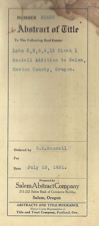
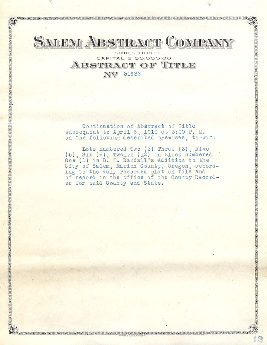
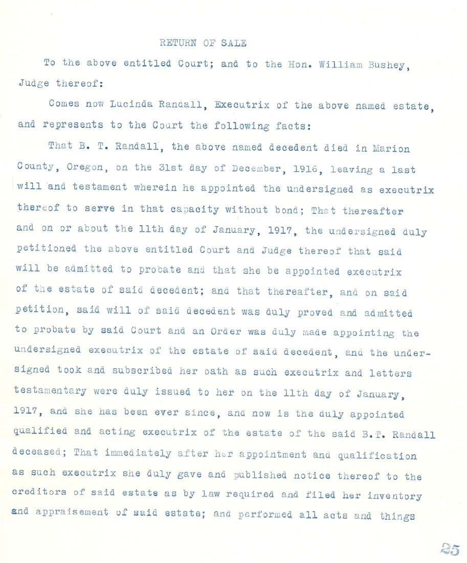
Abstract of Land Title #31632
David Leslie
Pioneer of 1837
![]()
Oregon Donation Land Claim #403 Marion County, OR; David Leslie, b. 1797 Cheshire Co, NH; arrived Oregon Sep 1837; settled claim 15 Apr 1851; m'd Adelia J. Jan 1844, Marion Co, Oregon Territory. Aff: Nathaniel W. Colwell, Agnes Davidson, Charles Bennett. [Genealogical Material In Oregon Donation Land Claims Vol I, abstracted from Applications by Genealogical Forum of Portland, Oregon 1957]
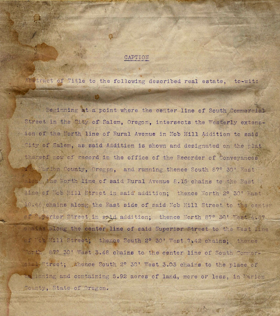
p. 1-2 Land description and Chain of Title
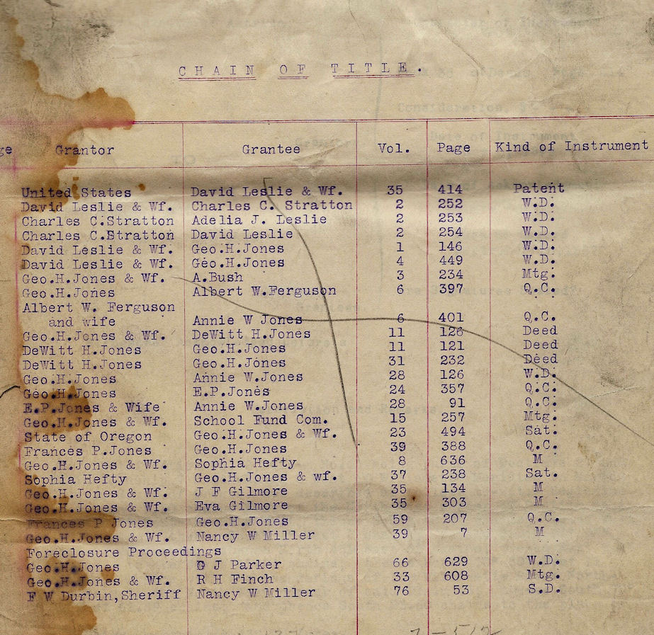
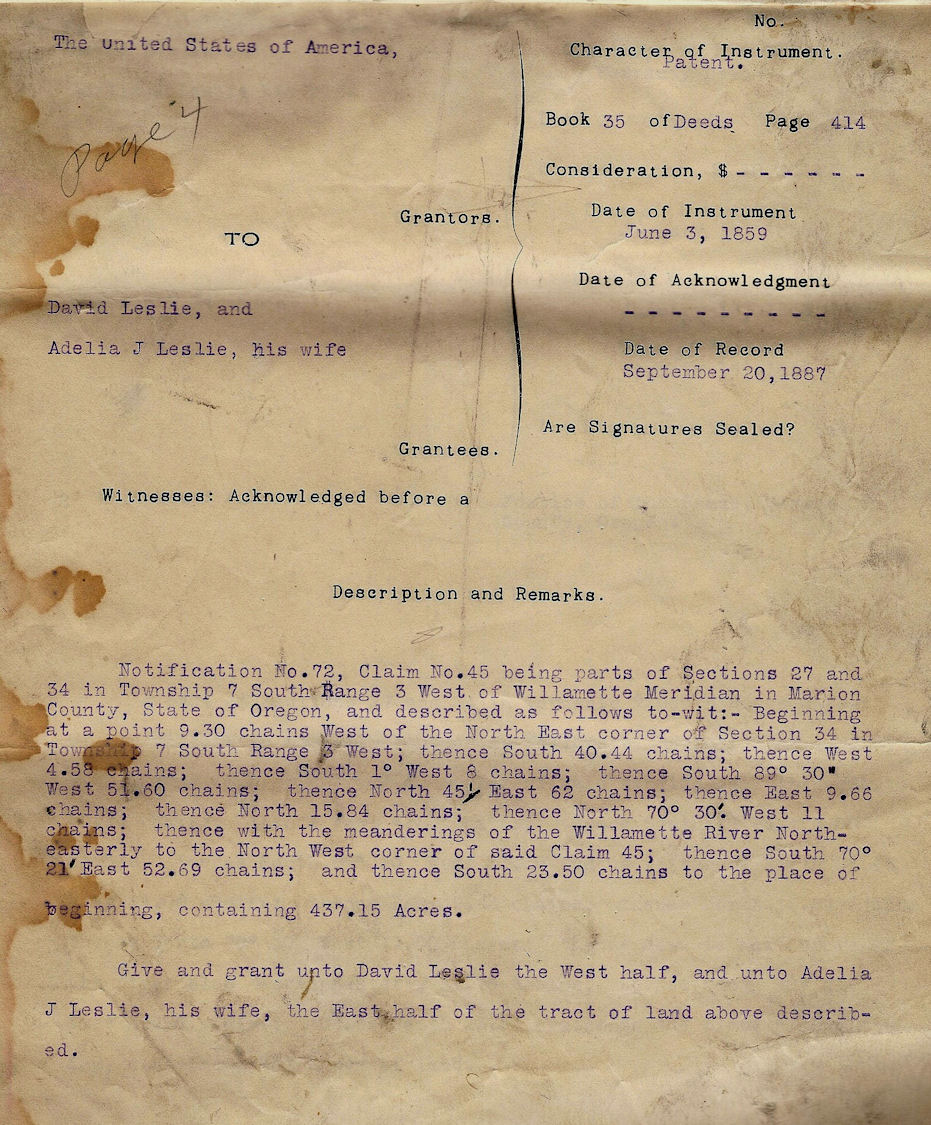
p. 3 Jun 3, 1859 USA, Grantor; David Leslie and Adelia J. Leslie, his wife, Patent/Deed
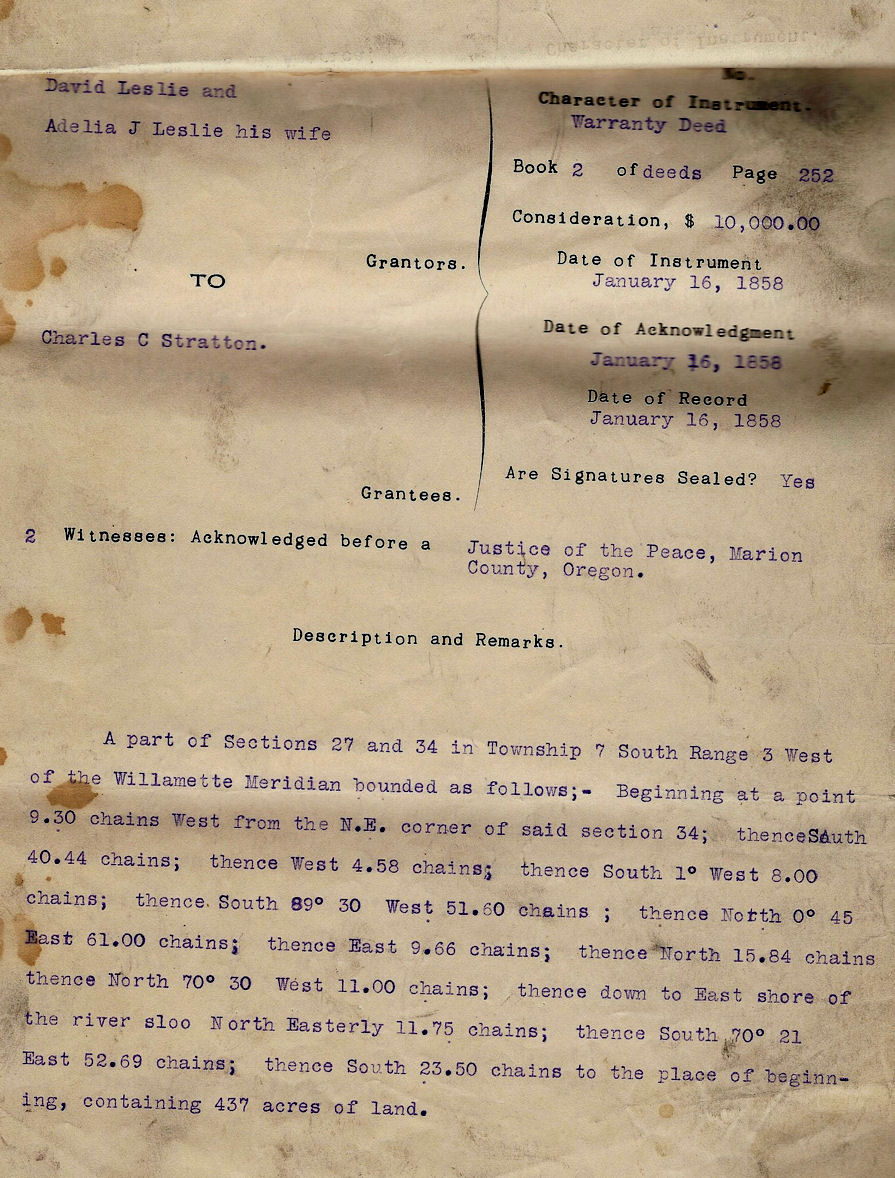
p. 4 Jan 16, 1858 David Leslie and Adelia J. Leslie, his wife, Grantors; Charles C. Stratton, Grantee; Warranty Deed $10,000;
p. 5 Jan 16, 1858 Charles C. Stratton, Grantor; Adelia J. Leslie; Warranty Deed $5,000
p.6 Jan 16, 1858 Charles C. Stratton, Grantor; David Lesley; Warranty Deed $5,000
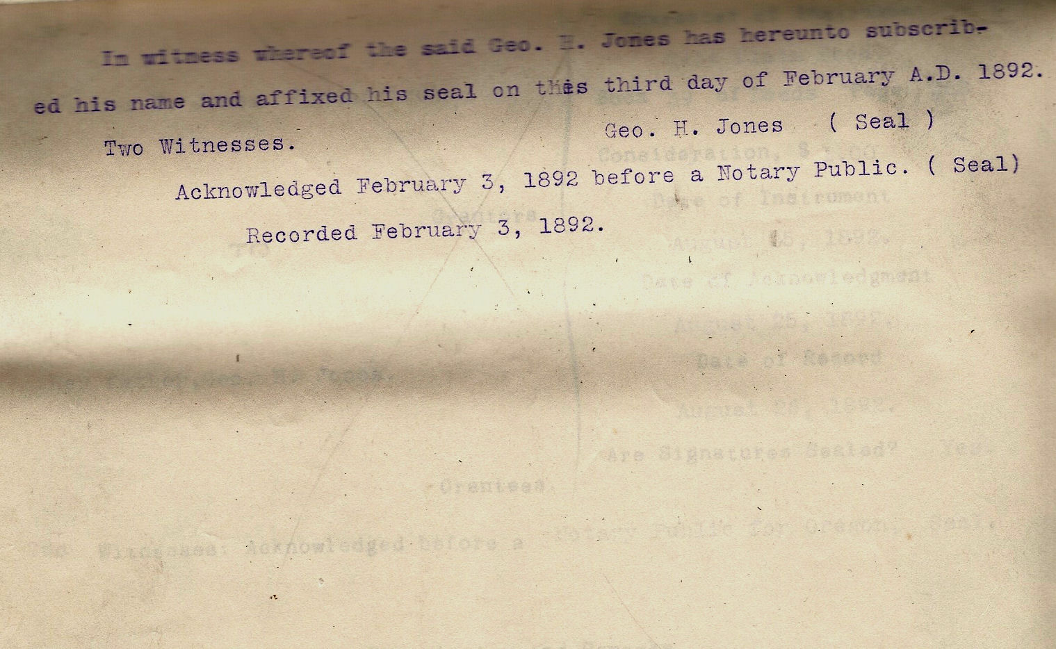
Sep 6, 1855 David Leslie and Adelia J. Leslie, his wife; Grantor; George H. Jones, Grantee; Warranty Deed $2000; commencing at a point in Fabritus Smith's line 10 chains and 47 links E of the SW corner of David Leslie's claim; thence N 88 chains and 58 links to W.H.Wilson's line; thence S 70° 21' E 12 chains and 7.5 links; thence S 84 chains and 80 links to a point on Fabritus Smith's line; thence S 89° 30' W 11 chains and 52.5 links to the place of beginning, containing 100 acres. Also beginning at the NW corner of above tract, thence N 70° 31' W 3 chains and 32 links to bank of Slough; thence SW on bank of Slough to Colwell's line on bank of Slough; thence S 70° 30' E 11 chains; thence 10 chains and 74 links to the place of beginning, containing 7.25 acres and making 107.25 acres.
Feb 3, 1859 David Leslie and Adelia J. Leslie, his wife; Grantor; George H. Jones, Grantee; Warranty Deed $2000; adjustment to description of lands in Sep 6, 1855 Warranty Deed; commencing in T7SR3W on the bank of the Slough of the Willamette River at the SW corner of the claim of William H. Wilson and wife; thence E along the S line of said claim to a point 12 chains and 7.5 links E of the center of the territorial road leading from Salem to Albany; thence S parallel with road 84 chains and 80 links to the S line of David Leslie's claim; thence W along said South line to the center of territorial road; thence N along the center of said road to a point where the N line of the land claim of N.W. Colwell extended, would intersect the same; thence N 70° 30'W with said N line so extended to the NW corner of said Colwell's claim; thence along the bank of the Slough NE to the place of beginning, containing 110 acres more or less.
Apr 3, 1861 George H. Jones and Annie W. Jones, his wife, Grantors; A. Bush, Grantee; Mortgage $1300; commencing in T7SR3W on the bank of the Slough of the Willamette River at the SW corner of the claim of William H. Wilson and wife; thence E along the S line of said claim to a point 12 chains and 7.5 links E of the center of the territorial road leading from Salem to Albany; thence S parallel with road 84 chains and 80 links to the S line of David Leslie's claim; thence W along said South line to the center of territorial road; thence N along the center of said road to a point where the N line of the land claim of N.W. Colwell extended, would intersect the same; thence N 70° 30'W with said N line so extended to the NW corner of said Colwell's claim; thence along the bank of the Slough NE to the place of beginning, containing 110 acres more or less. (mortgage satisfaction acknowkledged Nov 22, 1862)
Aug 22, 1863 George H. Jones, Grantor; Albert W. Ferguson, Grantee; Quit Claim Deed $2800; commencing in T7SR3W on the bank of the Slough of the Willamette River at the SW corner of the claim of William H. Wilson and wife; thence E along the S line of said claim to a point 12 chains and 7.5 links E of the center of the territorial road leading from Salem to Albany; thence S parallel with road 84 chains and 80 links to the S line of David Leslie's claim; thence W along said South line to the center of territorial road; thence N along the center of said road to the S line of William H. Willson and wife; thence E along the line of said claim to the place of beginning, (and other lands)
Aug 24, 1863 Albert W. Ferguson and Margaret J. Ferguson, his wife, Grantors; Annie W. Jones (wife of George H. Jones); Quit Claim Deed $8400; commencing in T7SR3W at a point on the S line of the claim of William H. Willson and wife and 12 chains and 7.5 links E of the center of the territorial road leading from Salem to Albany; thence S parallel with road 84 chains and 80 links to the S line of David Leslie's claim; thence W along said S line to the center of territorial road; thence N along center of territorial road to the S line of the claim of William H. Willson and wife, thence E along the lone of said claim to the place of beginning (and other lands)
Apr 15, 1865 George H. Jones and Annie W. Jones, his wife, Grantors; Thomas Cross, Grantee; Warranty Deed $200; commencing in T7SR3W in center of Territorial road from Salem to Albany at a certain point 4 chains and 31 links N of the N line of the land claim of F.R. Smith; thence E at right angles with said road 11 chains and 60 links or to the E line of said Jones land; being the line between said Jones and Cross; thence S on said line parallel with said road 4 chains and 31 links to the N line of the land claim of F.R. Smith; thence E along said line to the center of stage road; thence N along center of said road to the place of beginning, containing five acres more or less.
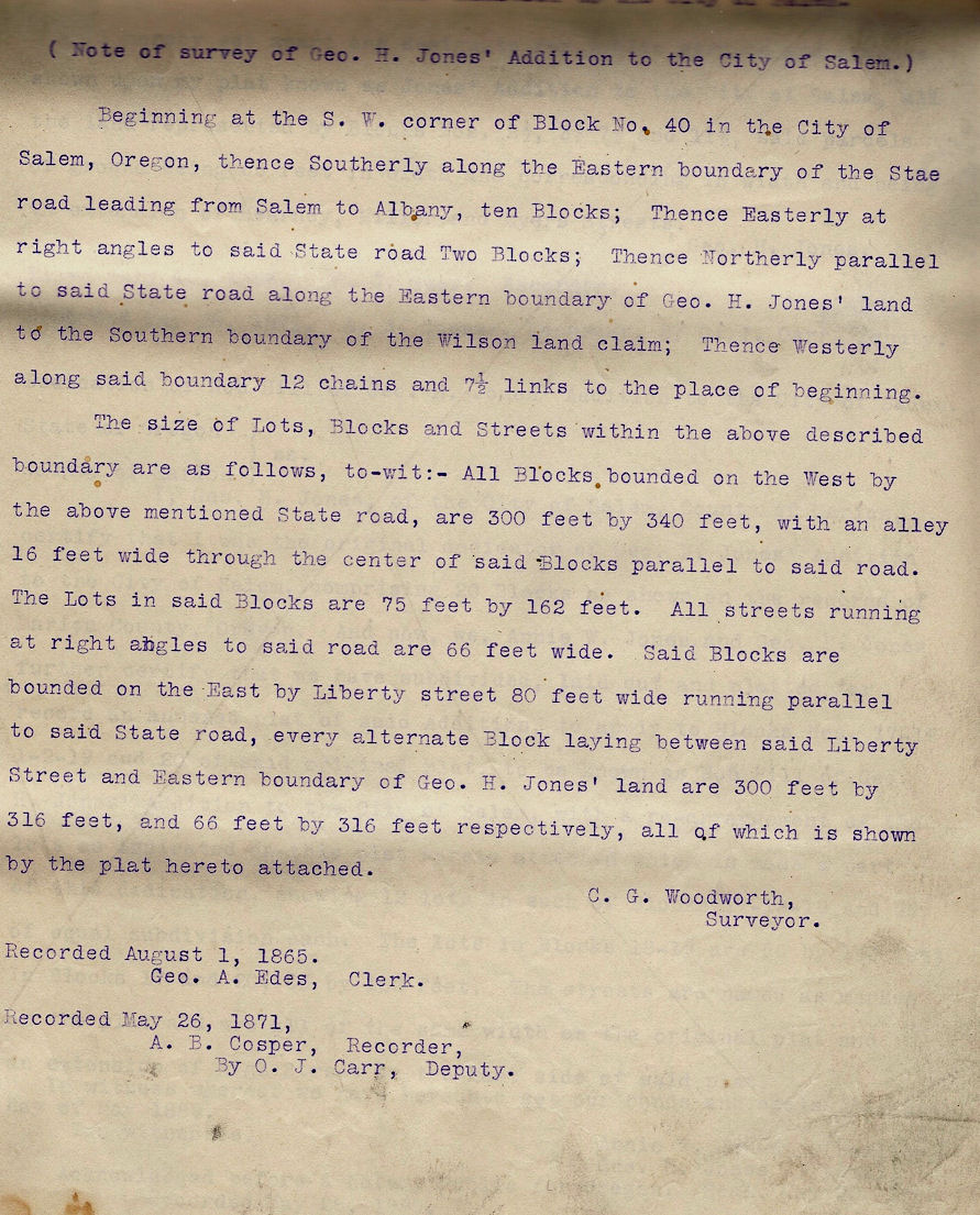
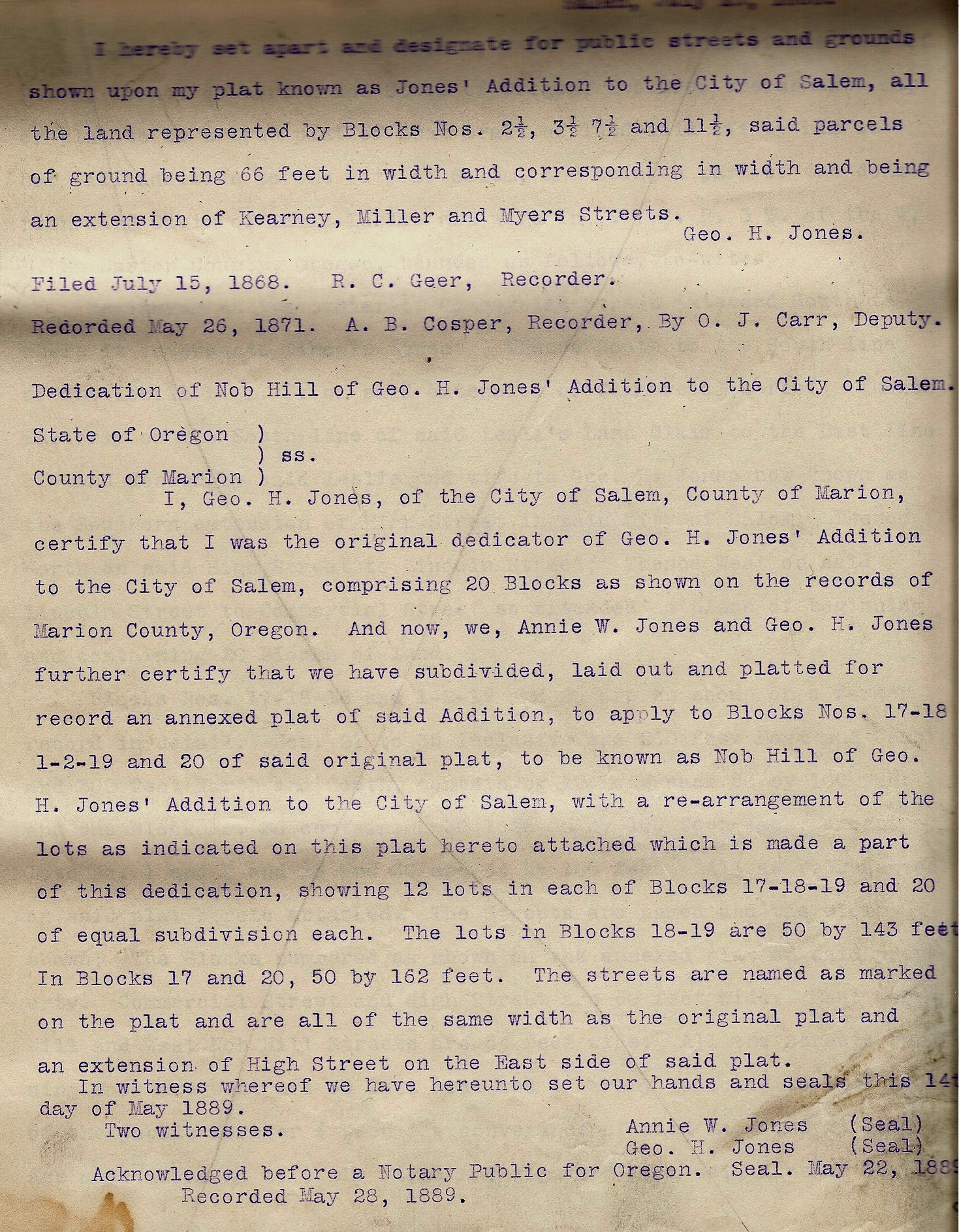
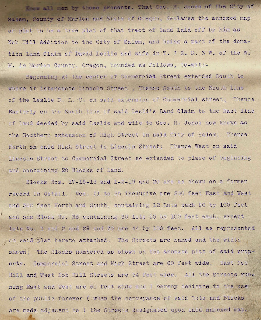
Aug 1, 1865 Jones Addition
Jun 22, 1869 George H. Jones and Annie W. Jones, his wife, Grantors; Dewitt H. Jones, Grantee; Deed $500 (witnessed in Santa Cruz Co, CA); commencing in T7SR3W at a point on the S line of the claim of William H. Willson and wife and 12 chains and 7.5 links E of the center of the territorial road leading from Salem to Albany; thence S parallel with road 84 chains and 80 links to the S line of David Leslie's claim; thence W along said S line to the center of territorial road; thence N along center of territorial road to the S line of the claim of William H. Willson and wife, thence E along the line of said claim to the place of beginning, being 100 acres more or less excepting said tracts of land heretofore conveyed to sundry persons in lots and parcels in Jones' Addition to the city of Salem, also Block 39 in City of Salem, Marion County, Oregon.
Jun 22, 1869 Dewitt H. Jones, Grantor; George H. Jones, Grantee; Deed $500; All those certain parcels and tracts of land deeded to me this day by George H. Jones and Annie W. Jones, his wife, excepting Lots 1, and 2 in Block 12 in Jones' Addition being described as follows: Block 39 in the City of Salem; also the parcel or tract of land containing 100 acres of land more or less described as commencing in T7SR3W at a point on the S line of the claim of William H. Willson and wife and 12 chains and 7.5 links E of the center of the territorial road leading from Salem to Albany; thence S parallel with road 84 chains and 80 links to the S line of David Leslie's claim; thence W along said S line to the center of territorial road; thence N along center of territorial road to the S line of the claim of William H. Willson and wife, thence E along the lone of said claim to the place of beginning excepting said tracts of land heretofore conveyed to sundry persons prior to the conveyance of George H. Jones and wife to me.
Jul 31, 1875 Thomas Cross and C.M. Cross, his wife, Grantors; George H. Jones, Grantee; Warranty Deed $250; commencing in T7SR3W in center of Territorial road from Salem to Albany at a certain point 4 chains and 31 links N of the N line of the land claim of F.R. Smith; thence E at right angles with said road 11 chains and 60 links or to the E line of said Jones land; being the line between said Jones and Cross; thence S on said line parallel with said road 4 chains and 31 links to the N line of the land claim of F.R. Smith; thence E along said line to the center of stage road; thence N along center of said road to the place of beginning, containing five acres more or less.
Dec 21, 1877 George H. Jones, Grantor; Annie W. Jones, Grantee; Sophia Hefty, Grantee; Mortgage $1000; in center of Territorial road leading from Salem to Albany on the line between the original DLC of David Leslie and wife and F.R. Smith and wife, thence E on the above line 11.61 chains to the land owned by the heirs of Pluma Cross, deceased; thence N parallel with the road 17.24 chains, thence W at right angles with the road 11.61 chaines to the center of said road; thence S along the center of said road 17.24 chains to the place of beginning containing 20 acres more or less to secure a note (notation in margin: For value received I do hereby assign, transfer, sell and set over to E.P. Jones of his order all my right, title and interest in this mortgage this 15th Feb 1882 per Sophia Hefty) (Satisfaction of the mortgage between Sophia Hefty and George H. Jones acknowledged Jan 7, 1896)
Jan 25, 1879 George H. Jones, Grantor; Annie W. Jones, Grantee; Warranty Deed $100 etc; commencing in T7SR3W at a point on the S line of the claim of William H. Willson and wife and 12 chains and 7.5 links E of the center of the territorial road leading from Salem to Albany; thence S parallel with road 84 chains and 80 links to the S line of David Leslie's claim; thence W along said S line to the center of territorial road; thence N along center of territorial road to the S line of the claim of William H. Willson and wife, thence E along the lone of said claim to the place of beginning, being 60 acres more or less excepting said tracts of land heretofore conveyed as shown by the records of Marion county and being a part of David Leslie and wife DLC in T7SR3W ; also the East half and the East half of the West half of Block 40 and subject to three mortgages amounting to about $2500
Nov 1, 1879 George H. Jones, Grantor; E.P. Jones, Grantee; Quit Claim Deed in consideration of the sum of $9900 and the surrender of his note by E.P. Jones of Findlay, OH for the sum of $4500 bearing date Sep 1, 1869 and payable five years from date with 1% per month interest to be paid; all his interest in equity in the following premises commencing in T7SR3W at a point on the S line of the claim of William H. Willson and wife and 12 chains and 7.5 links E of the center of the territorial road leading from Salem to Albany; thence S parallel with road 84 chains and 80 links to the S line of David Leslie's claim; thence W along said S line to the center of territorial road; thence N along center of territorial road to the S line of the claim of William H. Willson and wife, thence E along the lone of said claim to the place of beginning, being 60 acres more or less excepting said tracts of land heretofore conveyed as shown by the records of Marion county
Oct 25, 1880 Elijah P. Jones and Mellie E. Jones, his wife, Grantors; Annie W. Jones, Grantee; Quit Claim Deed $100 etc; commencing in T7SR3W at a point on the S line of the claim of William H. Willson and wife and 12 chains and 7.5 links E of the center of the territorial road leading from Salem to Albany; thence S parallel with road 84 chains and 80 links to the S line of David Leslie's claim; thence W along said S line to the center of territorial road; thence N along center of territorial road to the S line of the claim of William H. Willson and wife, thence E along the lone of said claim to the place of beginning, being 60 acres more or less excepting said tracts of land heretofore conveyed as shown by the records of Marion county and being a part of David Leslie and wife DLC in T7SR3W
Oct 17, 1883 George H. Jones, Grantor; Annie W. Jones, Grantee; Board of School Fund Commissioners, Grantees; Mortgage $1070; commencing in center of county road known as the Salem and Jefferson road at a point 17.24 chains N of the point when said road crosses the line between the DLC of David Leslie and wife and F.R. Smith and wife and running thence N along the center of said road to the S side of Johns Street, in George H. Jones' Addition to the City of Salem; thence E along the S side of said Johns Street to the E line of the land conveyed to George H. Jones by David Leslie and wife; thence S along said line to a point E and right angles to the place of beginning, containing 27 acres of land more or less. (Satisfaction of mortgage noted Feb 21, 1891)
Aug 25, 1892 Frances P. Jones (Unmarried), Grantor; Her father, George H. Jones, Grantee; Quit Claim Deed $1; all her right in law or in equity by inheritance or otherwise to the following premises: all that tract or parcel of land lying S of Blocks 15 and 16 in George H. Jones' first addition to the City of Salem being part of the original purchase by George H. Jones of David Leslie and wife, and also being a part of David Leslie DLC in T7SR3W
Mar 16, 1895 George H. Jones and Mary S. Jones, his wife, Grantor; J.F. Gilmore, Grantee; Mortgage $250; all of Block 22 in Nob Hill Addition (Mortgage satisfaction acknowledged Oct 31, 1895)
Jun 5, 1895 To the Honarable County Court of Marion County, State of Oregon. Gentlemen: I would respectfull represent to you that I am the proprietor and original dedicator of the Addition to Salem of a plat of grund recorded as Nob Hill plat. That there are no streets opened South of Superior Streets running East and West, except rural avenue and none North and South except High Street. That East and West Nob Hill streets as marked on the plat are not desirably located, consequently I would ask to declare all the Streets on said plat South of Superior Street, except High Street, and Rural Avenue, vacated. That I am able to relocate said Streets as may seem more desirable before making sale of any lots adjacent thereto. Respectfully, George H. Jones (petition granted July 5, 1895)
Oct 11, 1895 George H. Jones and Mary S. Jones, his wife, Grantor; Eva Gilmore, Grantee; Mortgage $275; all of Block 22 and Lots 5, 6, 7 and 8 in Block 17 in Nob Hill Addition (Mortgage satisfaction acknowledged Dec 3, 1895)
Feb 25, 1896 Frances P. Jones (a single woman) , Grantor; George H. Jones, Grantee; Quit Claim Deed $1; this deed given to correct property conveyed by her deed dated Aug 25, 1892; beginning in center of Commercial Street on the S line of the David Leslie and wife DLC being the SW corner of the tract of land deeded to Geo. H. Jones by David Leslie and wife in 1859; thence E on said S line 11.81 chains to the center of High Street extended; thence N parallel with Commercial Street 42.28 chains to a stake; thence W 11.63 chains to the center of Commercial street; thence S along the center of Commercial street 42.90 chains to a stake at the place of beginning containing 49.53 acres more or less.
Feb 26, 1896 George H. Jones and Mary S. Jones, his wife, Grantor; Mrs. Nancy W. Miller, Grantee; Mortgage $1500; beginning in center of Commercial Street on the S line of the David Leslie and wife DLC being the SW corner of the tract of land deeded to Geo. H. Jones by David Leslie and wife in 1859; thence E on said S line 11.81 chains to the center of High Street extended; thence N parallel with Commercial Street 9.45 chains in the center of High Street; thence parallel with Commercial Street 11.36 chains; thence E at right angles with Commercial Street 3.85 chains; thence N parallel with Commercial Street 5 chains; thence E at right angles with Commercial Street 3.48 chains to the center of High Street extended; thence N in center of High Street and parallel with Commercial Street 5.91 chains to the center of Superior Street; thence W at right angles with Commercial street 8.30 chains; thence S parallel with Commerical street 7.42 chains; thence W at right angles with Commercial Street 3.48 chains to the center of Commercial street; thence S in the center of said street 24.48 chains to the place of beginning containing 25 acres more or less.
Dec 20, 1897 George H. Jones and Mary S. Jones, his wife, Grantor; R.H. Finch, Grantee; Mortgage $100; Lots 1, 2, 3, 4 in Block 26 of Nob Hill Addition
Jun 22, 1898 George H. Jones, Grantor; G.J. Parker, Grantee; Warranty Deed $1; the same being mortgaged to Nancy W. Miller for $1500, which is a first lien on the lands described Feb 26, 1896
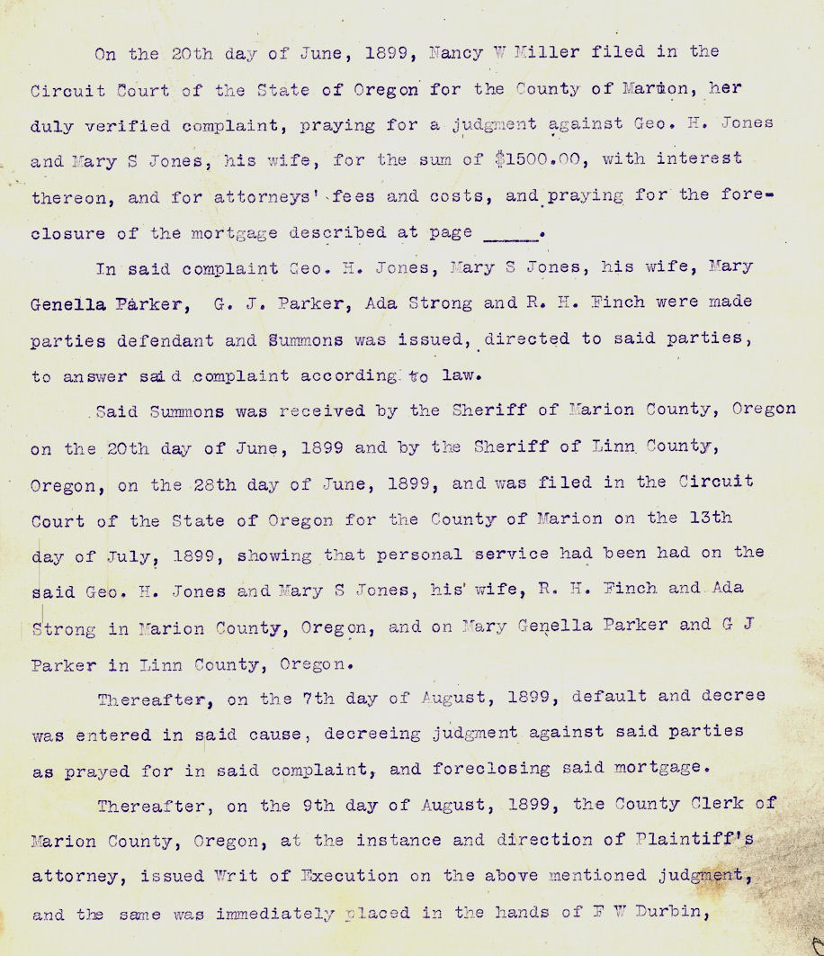
Jun 20, 1899 Nancy W. Miller files foreclosure proceedings agains George H. Jones for $1500 with interest
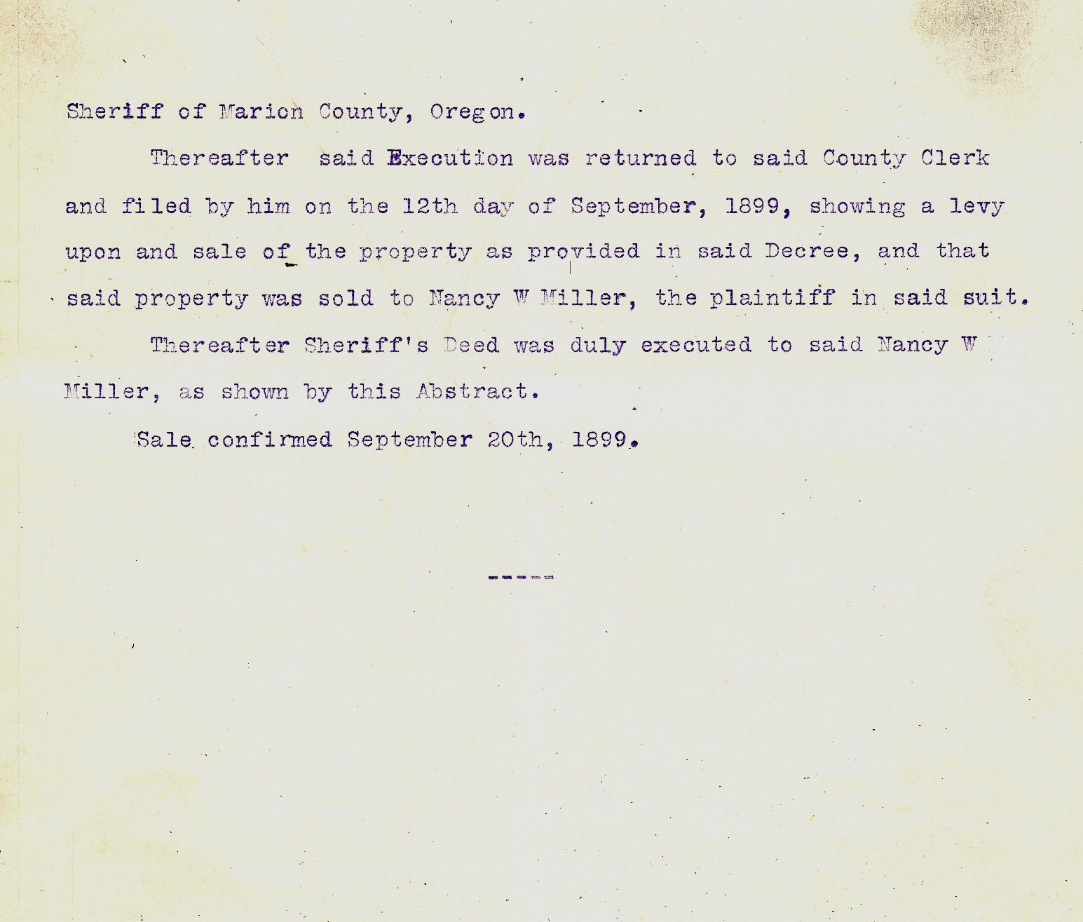
Sep 21, 1900 F.W. Durbin, Sheriff of Marion County, Grantor; Nancy W. Miller, Grantee; Sheriff's Deed $1883.77; beginning in center of Commercial Street on the S line of the David Leslie and wife DLC being the SW corner of the tract of land deeded to Geo. H. Jones by David Leslie and wife in 1859; thence E on said S line 11.81 chains to the center of High Street extended; thence N parallel with Commercial Street 9.45 chains in the center of High Street; thence parallel with Commercial Street 11.36 chains; thence E at right angles with Commercial Street 3.85 chains; thence N parallel with Commercial Street 5 chains; thence E at right angles with Commercial Street 3.48 chains to the center of High Street extended; thence N in center of High Street and parallel with Commercial Street 5.91 chains to the center of Superior Street; thence W at right angles with Commercial street 8.30 chains; thence S parallel with Commerical street 7.42 chains; thence W at right angles with Commercial Street 3.48 chains to the center of Commercial street; thence S in the center of said street 24.48 chains to the place of beginning containing 25 acres more or less.
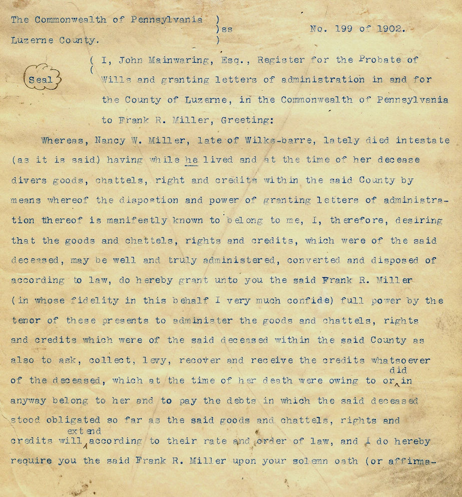
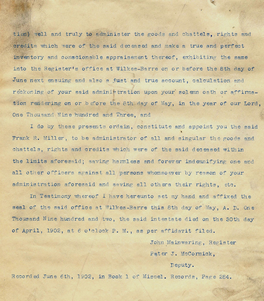
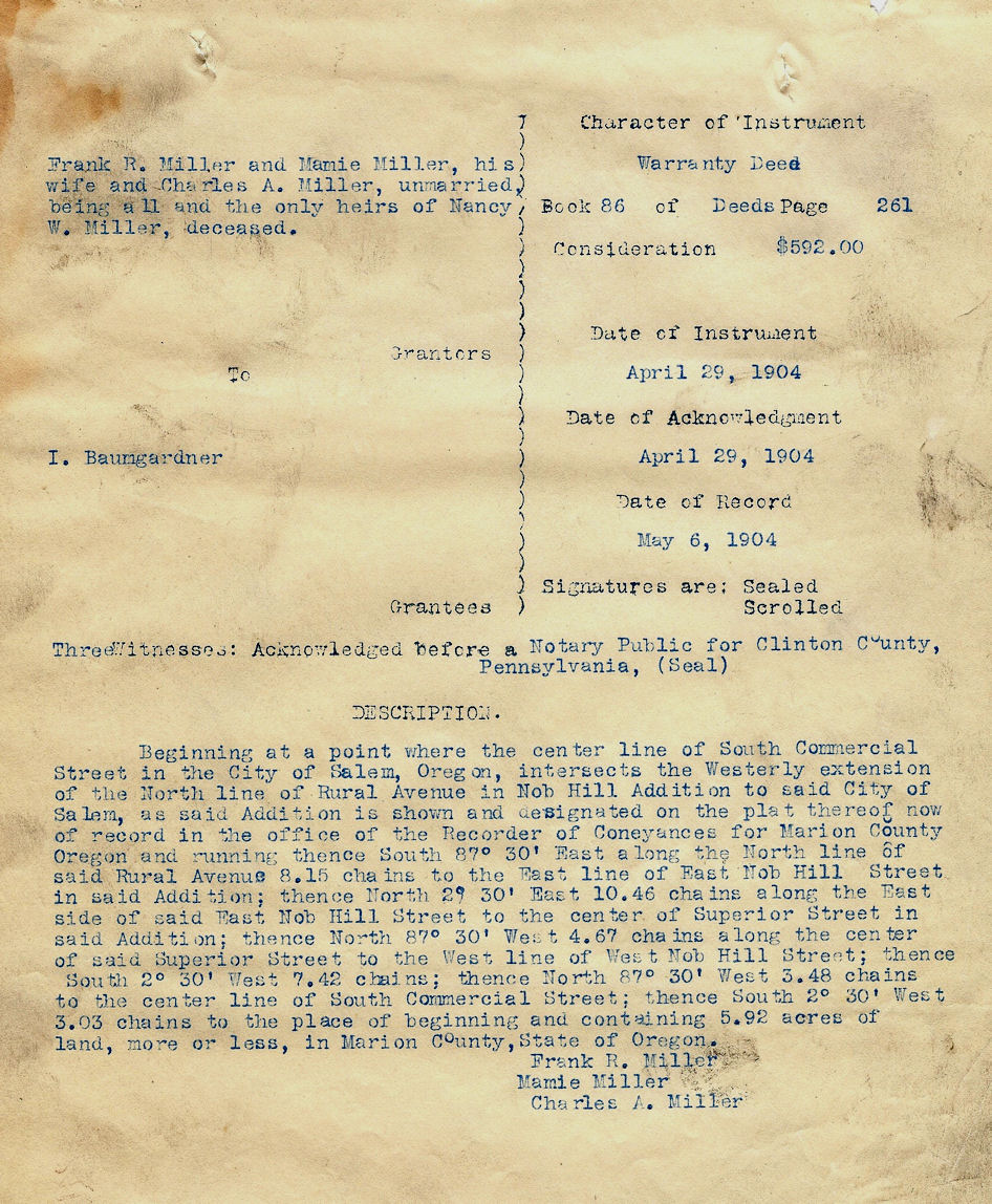
Jun 6, 1902 Probate of Nancy W. Miller will
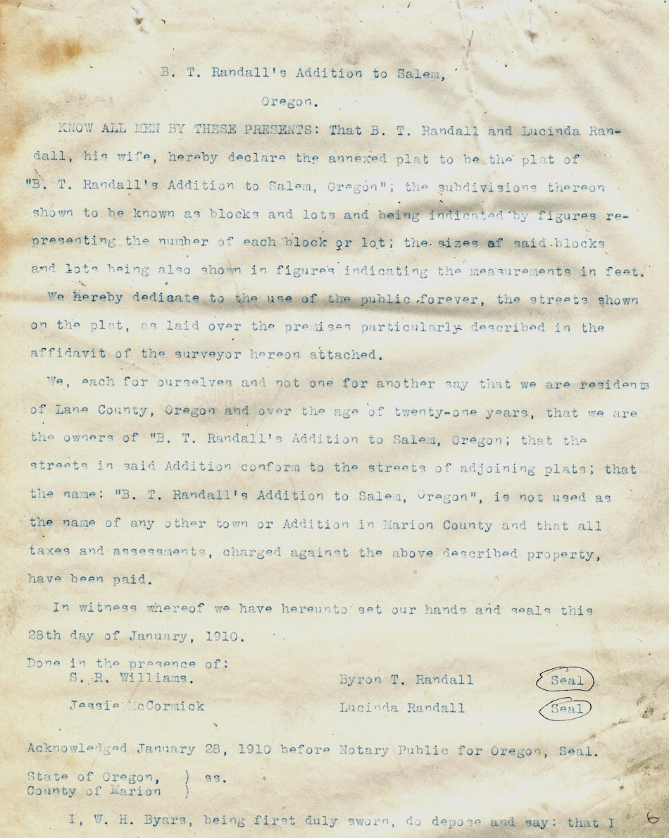
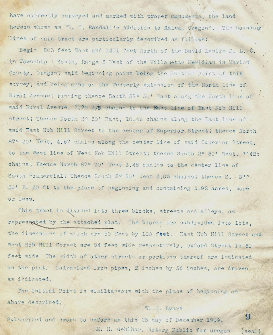
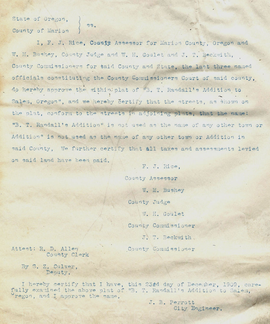
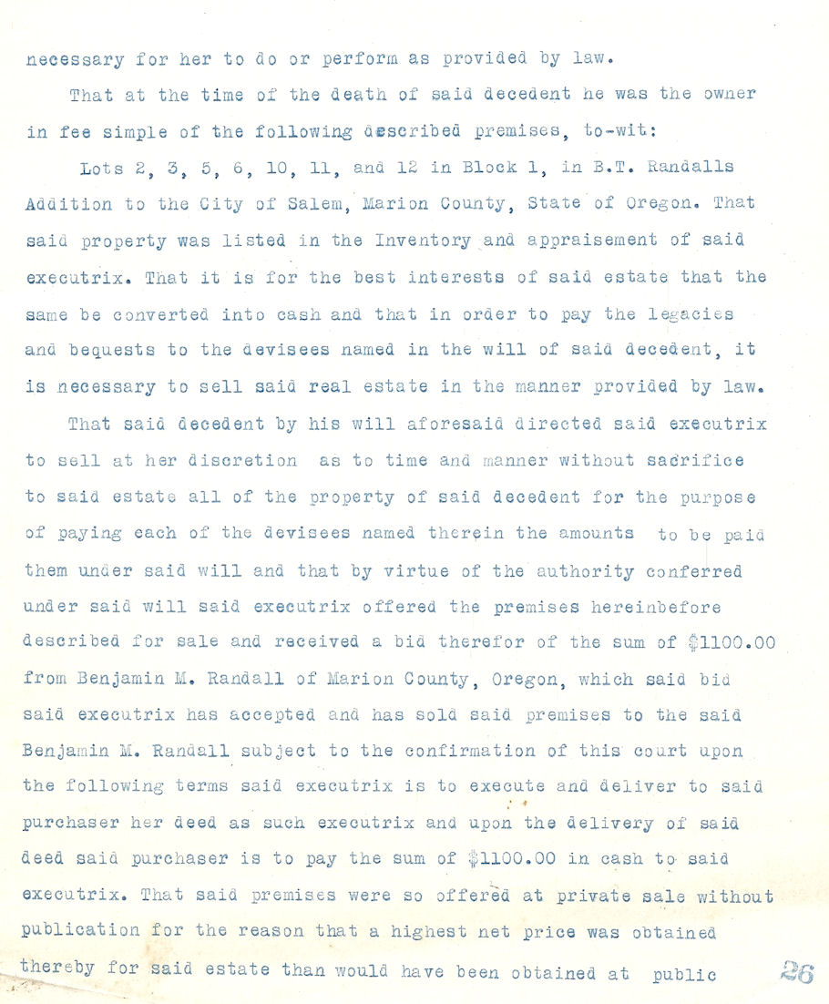
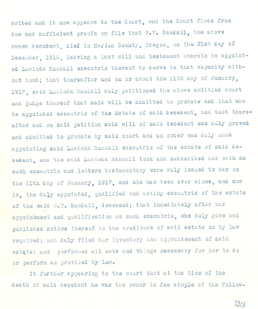
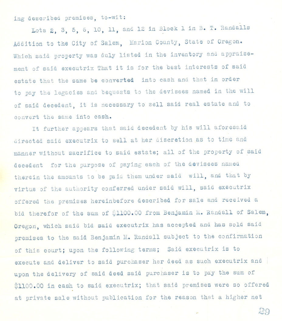
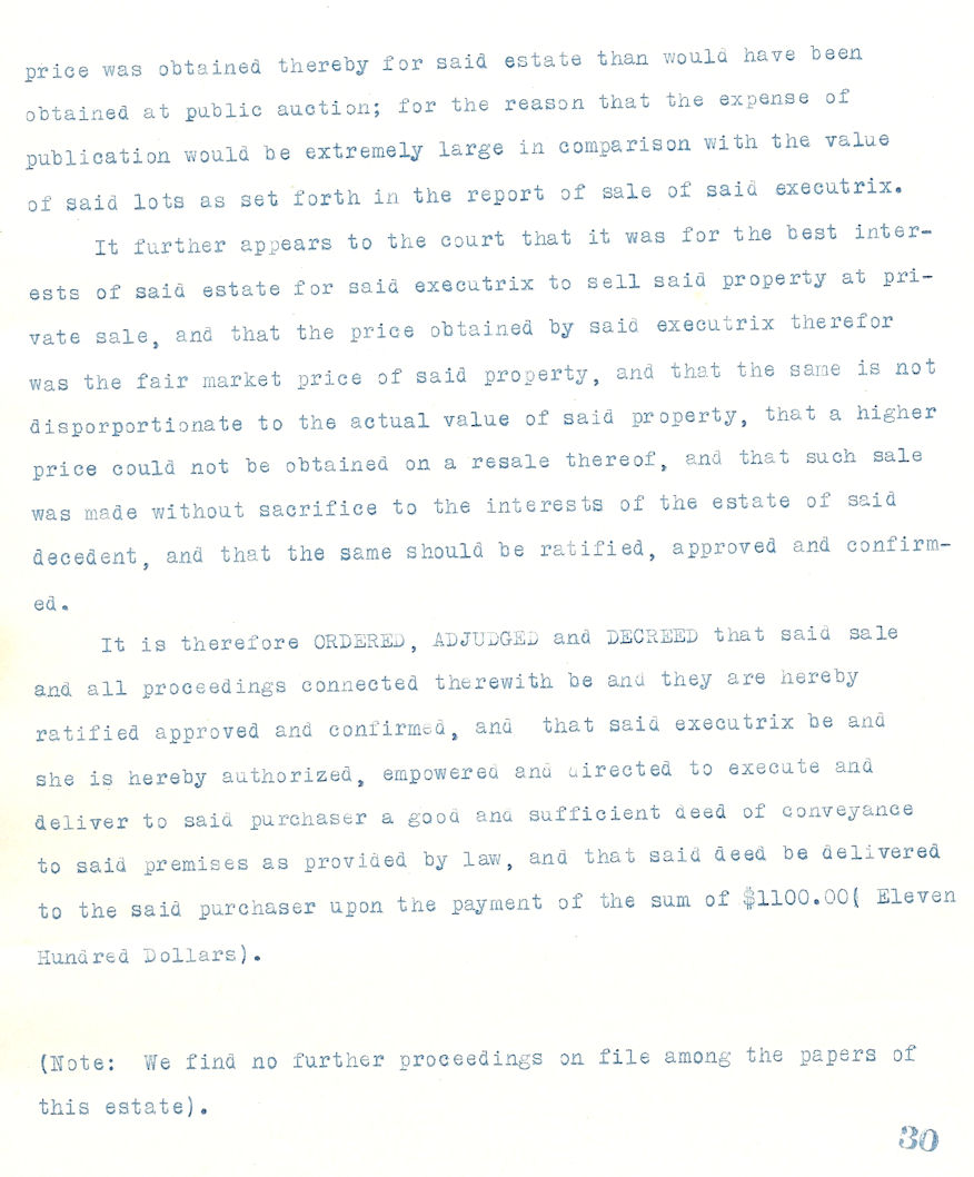
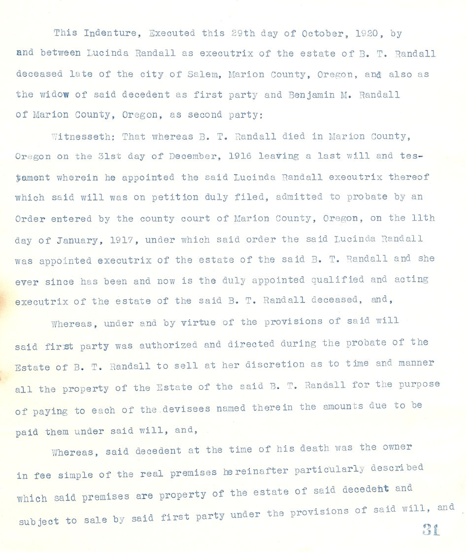
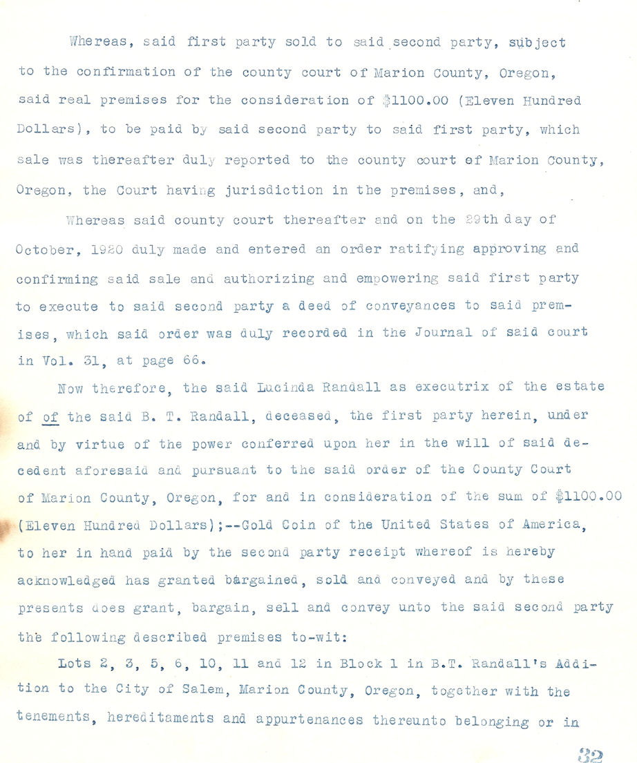
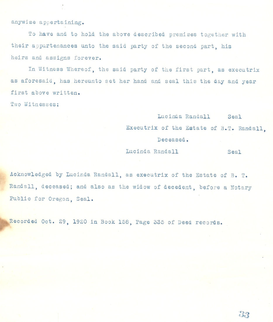
Oct 26, 1908 B.T. Randall Addition
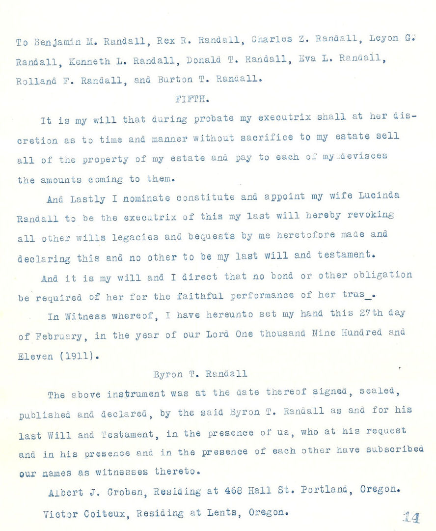
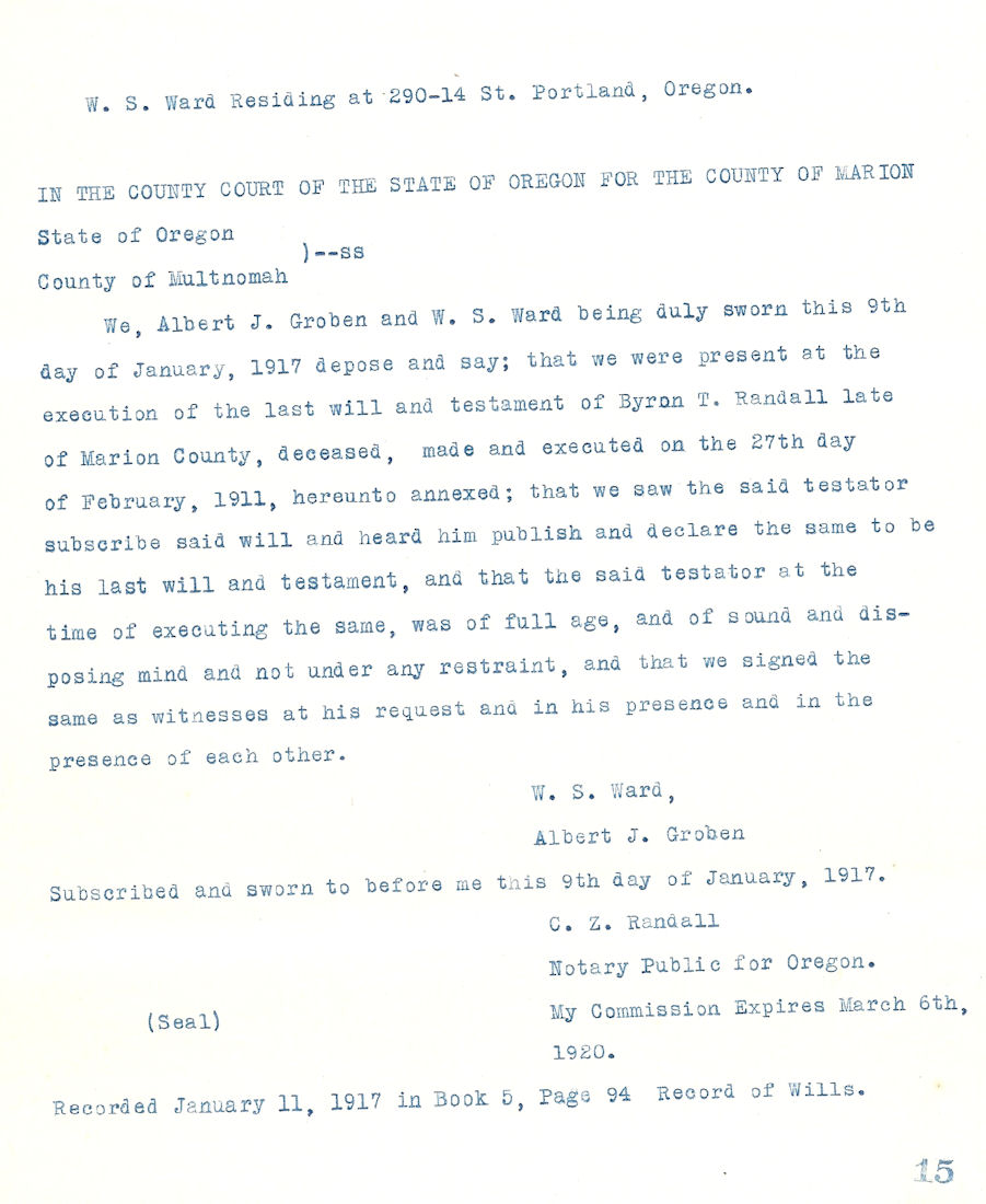
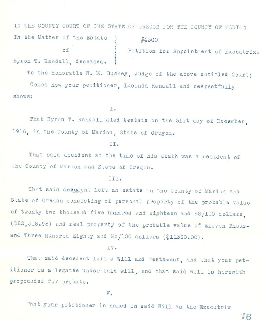
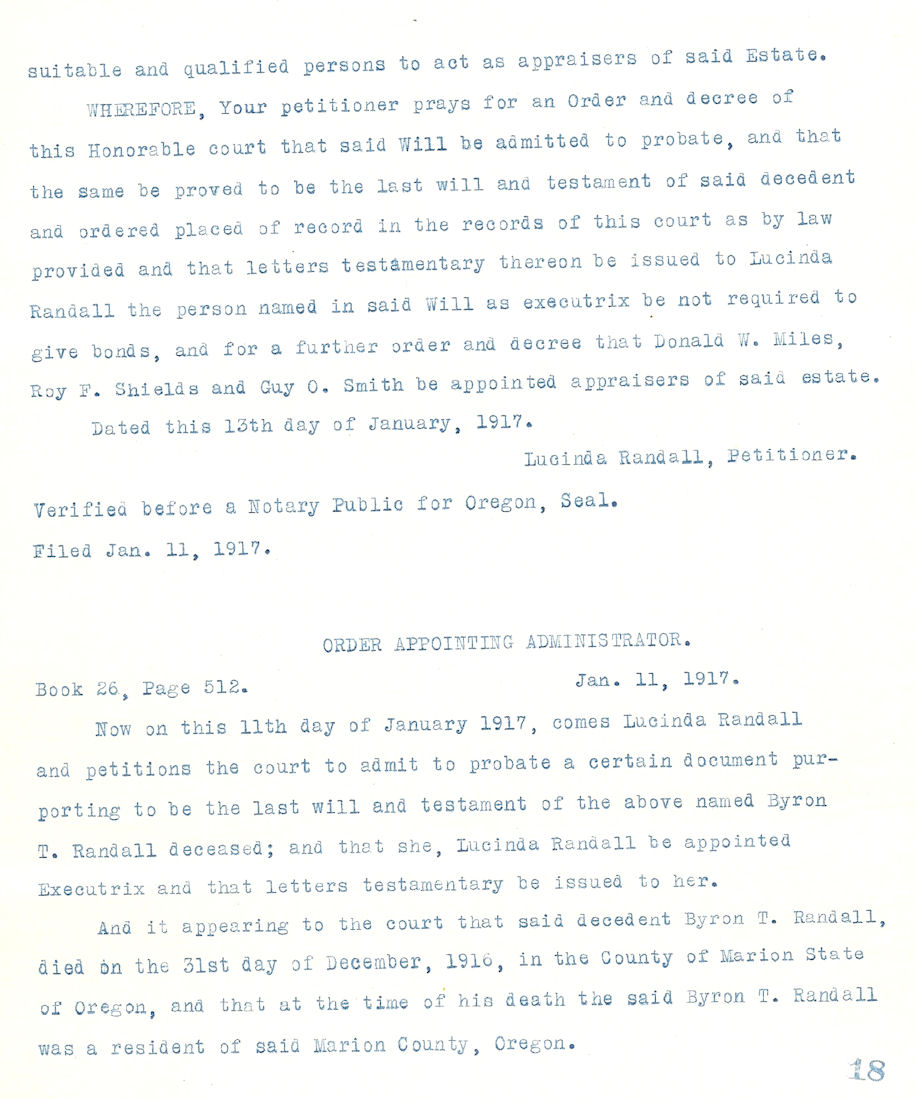
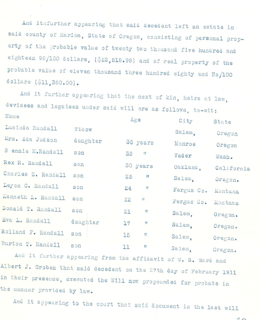
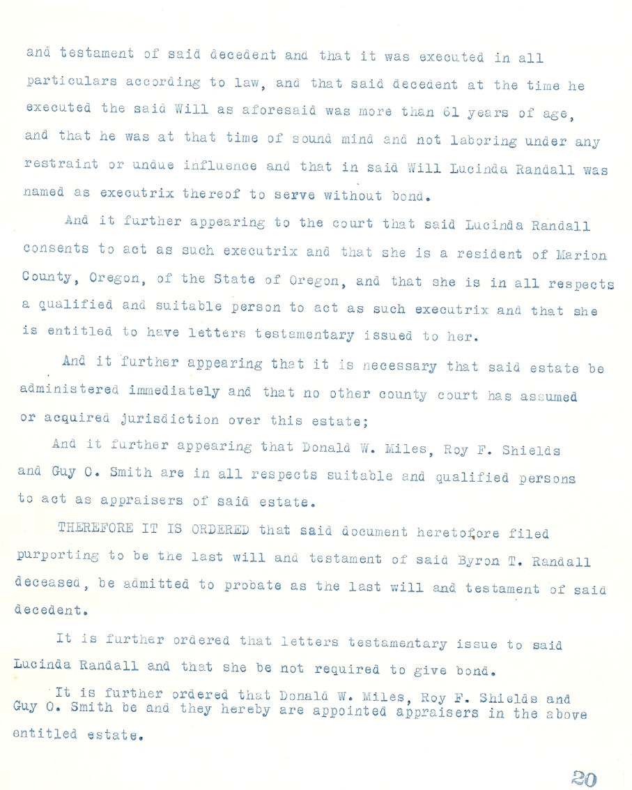
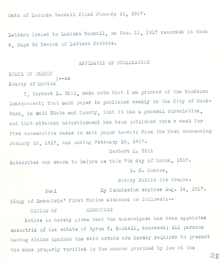
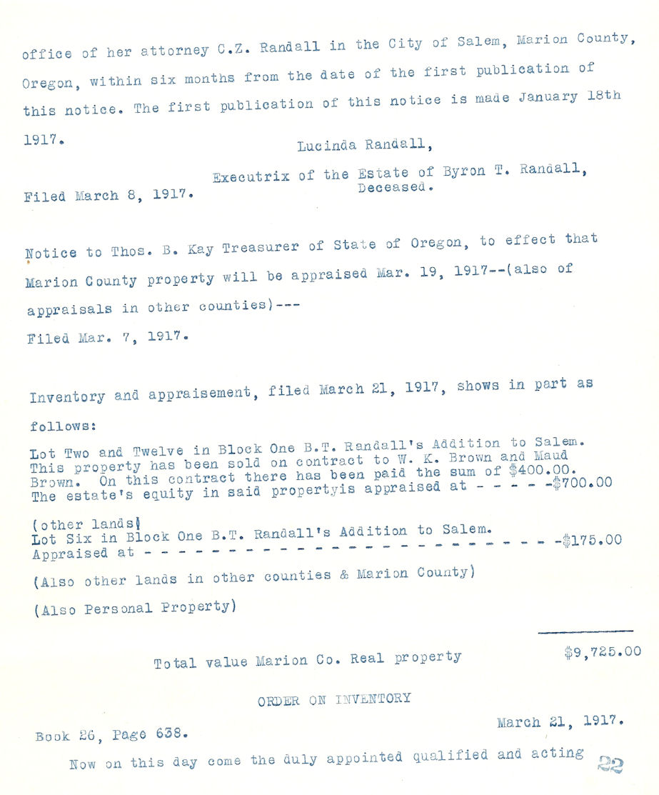
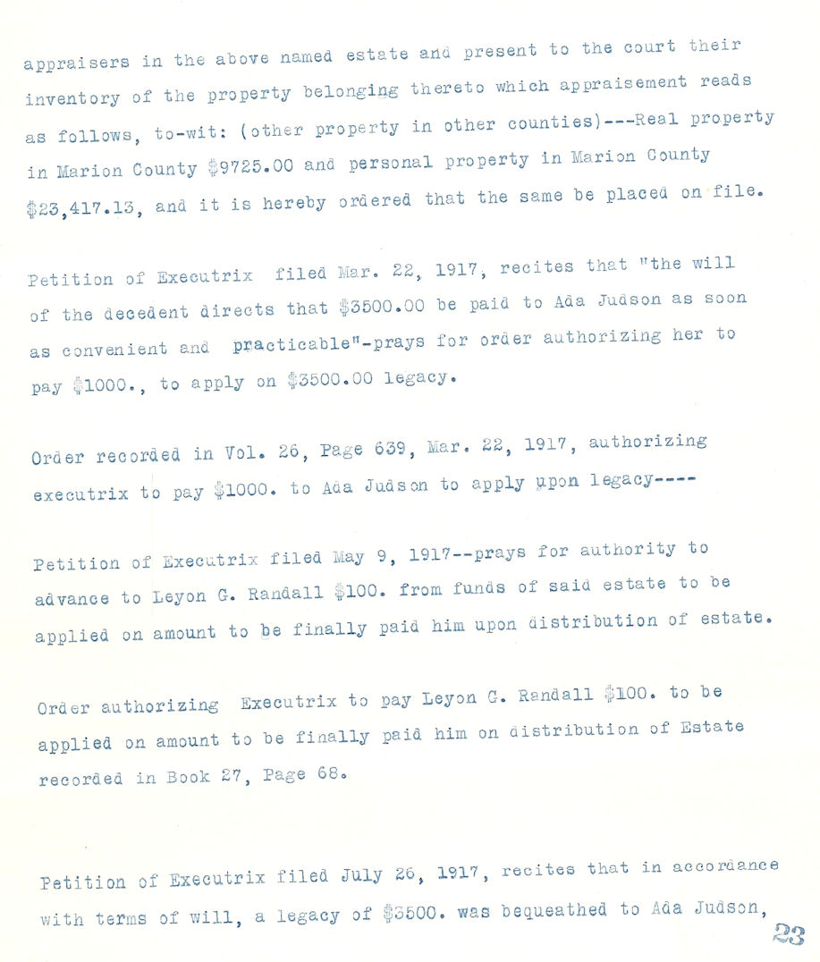
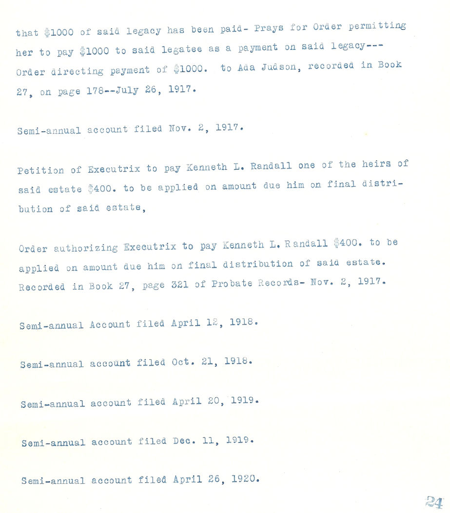
Feb 27, 1911 Byron T. Randall Will and Probate


![]()
My name is Stephenie Flora. Thanks for
stopping by. Return to [
Home Page ]
All [ Comments
and Inquiries ] are welcome.